Steinberg (Hohenberg an der Eger)
| Steinberg | ||
|---|---|---|
|
Steinberg with basalt hill (left) and Heiligenberg (right) seen from the southeast from Schirnding . |
||
| height | 653 m above sea level NHN | |
| location | Hohenberg an der Eger , District of Wunsiedel in the Fichtel Mountains , Bavaria ( Germany ) | |
| Mountains | Fichtel Mountains | |
| Coordinates | 50 ° 5 '44 " N , 12 ° 10' 50" E | |
|
|
||
| rock | basalt | |
| Last eruption | Miocene | |
The Steinberg ( 653 m above sea level ) is an elongated hill made of basalt from an extinct volcano west of the town of Hohenberg an der Eger in the Bavarian district of Wunsiedel in the Fichtel Mountains . It is located on the eastern edge of the Fichtel Mountains in the Fichtel Mountains Nature Park . The secondary peaks in the immediate vicinity are the basalt hill ( 652 m ) and the Heiligenberg ( 651 m ).
natural reserve
The Heiligenberg sub-area is a protected geotope . Its geoscientific value has been classified as "valuable" by the Bavarian State Office for the Environment. The basalt hill is a protected landscape area .
Economic use
Most of the forest belongs to the Bavarian State Forests and is used for forestry purposes. On the south side of the mountain there were clay pits that were mentioned in the land register of the six offices as early as 1499 . The found kaolins were the reason for the establishment of the porcelain factory in Hohenberg an der Eger in 1814. In 1928, the Upper Franconian ocher mine Kothigenbibersbach, based in Nuremberg, was operated by mining in a 27 meter shaft.
Small monuments
The memorial stone for Carolus Magnus Hutschenreuther , the founder of the porcelain industry, has stood in this area southwest of the mountain since 1958 . The writing plate made of blue-gray Wölsauer granite rests on four pieces of basalt and bears the inscription:
- "- CM HUTSCHENREUTHER -
FIND THE EARTH
HERE - FOR OUR PORCELAIN -
HOHENBERG - ARZBERG - SELB - SCHIRNDING
- 1814–1958"
Tourist development
The main hiking trail Mittelweg of the Fichtelgebirgsverein leads from Hohenberg across the Steinberg area, the Franconian mountain trail from Neuhaus an der Eger to Kothigenbibersbach touches the western foot of the mountain .
chapel
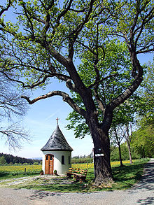
The Fatima Chapel is at the western foot of the mountain, at the Steinhaus forest restaurant. The developer is the private association for the construction and maintenance of a statue of the Virgin Mary. V. The inauguration took place in 2005. The chapel owes its name to the town of Fátima in Portugal, where Our Lady is said to have appeared to three shepherd children in 1917. The figure of Mary standing in a niche was made in Brazil, is made of ceramic or porcelain and was donated by Rome.
literature
- Andreas Peterek / Johann Rohrmüller: On the geological history of the Fichtelgebirge and its frame in: Der Aufschluss, issue 4 + 5/2010, p. 232.
- Friedrich Wilhelm Singer : The land book of the six offices from 1499 p. 364.
- Alfred Frank: The ocher pits at Steinberg near Thiersheim in: Narrator from Gabelmannsplatz of October 13, 1928, No. 23.
- Dietmar Herrmann: Steinhaus, Fatima Chapel and Hutschenreuther Memorial Stone in: Der Siebenstern 2007, p. 341.
Web links
- Bavaria-Fichtelgebirge: Geology of the Fichtelgebirge
- Bavaria-Fichtelgebirge: On the eastern edge of the Fichtelgebirge
- Bavarian State Office for the Environment, Geotope Cadastre Bavaria: Heiligenberg W von Hohenberg ad Eger (PDF; 1.5 MB)
Individual evidence
- ↑ Map services of the Federal Agency for Nature Conservation ( information )
- ↑ The Fatima Chapel. Retrieved December 2, 2019 .


