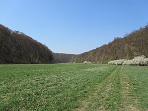
Helbetal
| Helbetal | |
|---|---|
|
The Helbetal west of Sondershausen |
|
| location | Thuringia , Germany |
| Waters | Helbe |
| Geographical location | 51 ° 23 ' N , 10 ° 38' E |
| rock | Shell limestone |
| length | 13 km |

The Helbetal , also Oberes Helbetal , is a nearly 14 kilometer long valley in the western Kyffhäuserkreis and a minimal part in the district of Nordhausen in northern Thuringia .
geography
Location and course
The Helbetal includes the part of the valley that accompanies the Helbe , which cut into the shell limestone of the north-western edge plates of the Thuringian basin up to 100 meters deep . It separates the ridges of the Hainleite in the northeast and the Dün in the west. Thin and Hainleite merge into one another in a comparatively smooth manner in ridges, so that a clear distinction is more difficult here.
The stone ditch on the Dün from the west ( Hüpstedt - Keula ) forms a source arm of the Helbe, but due to the strong karstification in the shell limestone, it only carries water after heavy rainfall or snowmelt. From Holzthaleben, the actual Helbetal then runs in a north-easterly direction. After about three kilometers, another spring arm flows from the direction of Friedrichsrode and the valley continues with a sharp bend to the southeast. At Wiedermuth it reaches the Thuringian Basin as the middle Helbetal .
Localities
The Helbetal itself is not populated, but the following villages are in the vicinity:
- Holzthaleben in the west
- Friedrichsrode in the northwest
- Kleinberndten in the northeast
- Dietenborn in a north-eastern side valley
- Großberndten in the east
- Himmelsberg in the southeast
- Wiedermuth in the south
- Toba in the southwest
- Big brother in the southwest
In terms of traffic, the lower section of the valley is accessible by the L 1033 from Kleinberndten and the L 2080 from Himmelsberg to Toba.
Historical settlements were near the Helbeburg with the desert of Helbe and other submerged places such as Schierenberg (today the so-called Backhaus), Ingelstedt, Harzungen.
Side valleys
As a result of erosion, several side valleys flow into the heavily divided plateau :
- Gloomy ground northeast of Holzthaleben (left side)
- Wolfental northeast of Holzthaleben (left side)
- Feuergrund southeast of Friedrichsrode (left)
- Martinsgrund from the north (on the left)
- Deep valley north of Kleinberndten (left side)
- Schinderloch northwest of Großbrüchter (on the right)
- Ingelstedter Grund northwest of Großbrüchter (on the right)
- Dietenborn south of the village of Dietenborn (on the left)
- Habichtstal southwest of Großberndten (left side)
- "Das Tal" north of Himmelsberg (left side)
mountains
The Helbetal is bordered by numerous mountain ledges and elevations of the Dün and the Hainleite:
- left side:
- Wedemark (approx. 440 m) east of Friedrichsrode
- Feuerkopf (435.3 m) between Friedrichshöhe and Kleinberndten
- Schweinsrück (415.9 m)
- The Riesern (approx. 415 m) northwest of Kleinberndten
- Nonnenberg (408.4 m) southwest of Kleinberndten
- Großer Mühlberg (approx. 370 m) south of Großberndten
- Mittelberg (350.7 m) south of Himmelsberg
- right side:
- Feldberg (approx. 435 m) northeast of Holzthaleben
- Helbeburg (approx. 420 m)
- Alte Hagen (408.0 m)
- Riethberg (406.5 m) north of Großbrüchter
- Herrenrode (338.4 m) east of Toba
nature
The valley with its steeper slopes and plateaus is predominantly forested (mixed beech forest), in the valley meadows there are meadows. To protect the landscape and rare plants and animals, the following protected areas have been designated:
- NSG Feuerkopf (61 hectares)
- NSG Himmelsberg (86 ha)
- on the southern edge of the NSG Holzenberg (85 ha)
- the Helbetal as the eastern part of the LSG Dün-Helbetal.
The water flow of the Helbe varies greatly over the seasons, especially in the upper section of the valley due to the karst features. Only in the lower section does it carry water relatively regularly, so that several mills were previously operated there.
Worth seeing
The Helbetal is connected to the surrounding towns by numerous hiking trails. Sights are:
- Wall systems of the Helbeburg northeast of Holzthaleben
- the Kuxloch, a karst fissure 43 meters deep near the Helbeburg
- Steinerne Jungfrau, a stone cross, southeast of Friedrichsrode
- Dr. Klemm memorial stone west of Himmelsberg
- Forest house
literature
Rudi Schulz: The upper Helbetal Sondershausen 1986, 20 pages
Individual evidence
- ↑ Hydrogeological map of Thuringia from the Thuringian State Institute for Environment and Geology (PDF; 4.37 MB) ( Even finer maps are available for each district .)
- ↑ Map services of the Federal Agency for Nature Conservation ( information )


