Holzthaleben
|
Holzthaleben
Helbedündorf municipality
Coordinates: 51 ° 20 ′ 28 " N , 10 ° 35 ′ 25" E
|
||
|---|---|---|
| Height : | 413 (375-420) m | |
| Residents : | 963 (Jun. 30, 2011) | |
| Incorporation : | November 25, 1993 | |
| Postal code : | 99713 | |
| Area code : | 036029 | |
|
Location of Holzthaleben in Thuringia |
||
|
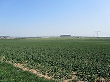
Holzthaleben from the south
|
||
With about 1000 inhabitants, Holzthaleben is the largest district and the seat of the municipality of Helbedündorf in the western part of the Thuringian Kyffhäuserkreis .
geography

Geographical location
Holzthaleben lies on the border of the two ridges, the Dün and Hainleite, on a limestone plateau on the north-western edge of the Thuringian Basin . In the plateau rising to the north , the upper valley of the Helbe opens - as an anomaly - in an arc to the north-west to flow back to the south. The place itself lies at an altitude between approx. 375 m above sea level (NHN) and 420 m above sea level, with the largest part of the place in a valley basin in the headwaters of the Helbe.
The highest natural point is reached at 498.1 m above sea level in the northwest of the district in the Holzthalebener forest. Other notable elevations are the Lorenzkopf (455.3 m above sea level), the Watte (443.0 m above sea level), the Feldberg (436.6 m above sea level) and the Mehlisch (430.9 m above sea level). The lowest point is on the eastern boundary of the district in Ingelstedter Grund at about 330 m above sea level.
The nearest larger cities are Mühlhausen / Thuringia (approx. 16 km), Sondershausen (approx. 23 km), Leinefelde-Worbis (approx. 24 km) and Nordhausen (approx. 35 km).
Neighboring communities
The following places or districts border the district - starting clockwise in the west: Keula (district of Helbedündorf), Rehungen (district of Sollstedt ), Friedrichsrode , Großbrüchter , Kleinbrüchter (all districts of Helbedündorf), Menteroda (districts Urbach and Menteroda).
history
The area around today's municipality was already settled in the younger Stone Age and in the Bronze Age, which is proven by various finds in the area around the town. The settled in early times in the northern Thuringia Celts attributed to the investment of the north of the village located Helbeburg, it is in a Wallenburg acted. It also played a role after the Germanic conquest, at least until the fall of the Thuringian Empire in 531, and offered protection for the neighboring residents. Roman coins were found in the locality, which document trade with the Roman Empire.
The existence of the place is documented since the year 846. The oldest document concerning Holzthaleben dates from the year 876. It says that the place existed already 30 years earlier. In it, Ludwig the German , at the time King of the East Franconian Empire , made a decision on the tithe in favor of the Fulda Abbey . In contrast to this, Wolfgang Kahl has a first documentary mention on March 20, 1143.
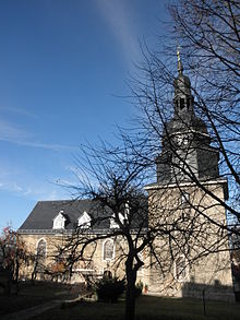
In the following centuries, the place developed into one of the largest villages in the area. This happened despite the inhospitable climate , the poor soil and the wars and epidemics that plagued the community again and again . A pastor was mentioned as early as 1251. The oldest part (tower) of the parish church dates from the period between 1250 and 1300. In 1562 the tavern was built. A municipal code was issued in 1563.
The Thirty Years War (1618–1648) hit Holzthaleben hardest of all wars in its recorded history. Much of the population was displaced or killed during the horrors of war. The troops of Count zu Pappenheim looted the place completely in 1632. In 1646 there were only 62 houses left in the village. As a result of the war, the community was so impoverished that not even a pastor could be paid. Most of the land was no longer cultivated.
In the years 1682/1683 the place suffered from the plague . In 1744/1745 a large part of the village was destroyed by fire. The church was also affected.
The Seven Years' War (1756–1763) and the Wars of Liberation against Napoléon I (1813–1815) also affected the community with billeting of soldiers, recruiting and war taxes.
The industrial age began in Holzthaleben in the second half of the 19th century . In the sixties of the century the road from Großbrüchter via Holzthaleben to Keula was built. In June 1881 the place was connected to the telephone network. Two steam mills were built in 1889.
The positive development of the place initially continued in the first half of the 20th century . With the commissioning of the Greußen-Ebeleben-Keulaer Railway in 1901, Holzthaleben was also connected to the railway network. A dairy was built in 1905. The beginning of potash mining in 1909 in neighboring Menteroda brought a further upswing.
The First World War (1914–1918) claimed 46 victims in the community.
During the Nazi regime , the NSDAP local group leader and other supporters of the church party “ German Christians ” had a swastika affixed to the church tower in 1934 , which was emblazoned over the place for eleven years. On a postcard it was announced that the place with its tower crown has the first church tower swastika of the German Empire. Actually, symbols of this type were supposed to be removed again in 1939 by order of Gauleiter Sauckel , but until the spring of 1945 it was still on the top of the church tower. Only shortly before the US troops marched in, fear of retaliation gave some of the residents the idea of removing the swastika. A local Ukrainian slave laborer carried out the rescue operation.
In the Second World War (1939-1945) a total of 96 residents of the place fell or were missing.
After the war, Holzthaleben had the highest number of inhabitants in its history due to the influx / accommodation of displaced persons.
Like all of Thuringia, Holzthaleben was handed over by the Americans to the Red Army at the beginning of July 1945 , making the place part of the Soviet Zone and, from 1949, of the GDR . The usual expropriations without compensation followed, and in the 1950s the collectivization of agriculture.
Due to a lack of profitability, passenger traffic on the Ebeleben - Keula railway was stopped on November 30, 1969 .
Holzthaleben has been part of this new community since the founding of the Helbedündorf community on November 25, 1993.
Population development
| year | population | comment |
|---|---|---|
| 1578 | 750 | |
| 1641 | 134 | |
| 1646 | 193 | |
| 1656 | 425 | |
| 1729 | 1300 | |
| 1806 | 1024 | |
| 1846 | 1178 | |
| 1934 | 1320 | |
| 1939 | 1255 | |
| 1946 | 1627 | |
| 1950 | 1926 | 500 refugees |
| 1955 | 1789 | |
| 1989 | 1277 | |
| 2000 | 1145 | |
| 2005 | 1101 | |
| 2010 | 971 | As of December 31, 2010 |
Town twinning
Since 1991 there has been a community partnership with Maxdorf in the Rhein-Pfalz-Kreis .
Culture and sights
Museums
There is a local museum in the village that documents the history of Holzthaleben. It was set up in the oldest bakery in the community, a listed half-timbered house .
Natural monuments
To the south-east of the village there is a 4-hectare nature reserve called Mehlisch Hölzchen .
A few kilometers to the north are the remains of the Helbeburg, a medieval hill fort.
Economy and Infrastructure
economy
The local economy is characterized by agriculture, forestry and handicrafts.
traffic
The place is connected to the road network by the state roads 1032 (Leinefelde - Ebeleben ) and 2096 (Holzthaleben - Schlotheim - Issersheilingen ).
Since the completion of the connection point Bleicherode on the federal motorway 38 ( Göttingen - Leipzig ), the next motorway connection is about 21 km from the town.
Until the end of passenger traffic on the Ebeleben - Keula line in 1969, there was a connection to the railway network . Since then, Holzthaleben can only be reached with various bus connections within the framework of local public transport .
Individual evidence
- ^ Homepage of the community of Helbedündorf. ( Page no longer available , search in web archives ) Info: The link was automatically marked as defective. Please check the link according to the instructions and then remove this notice. Retrieved July 14, 2012.
- ^ Wolfgang Kahl : First mention of Thuringian towns and villages. A manual. Rockstuhl Verlag, Bad Langensalza, 2010, ISBN 978-3-86777-202-0 , p. 128
- ↑ Hans Prolingheuer, Hitler's pious iconoclasts. Church & art under the swastika, Dittrich Verlag Cologne 2001, p. 66, ISBN 3-920862-33-3
- ↑ Heimatverein Holzthaleben eV (Ed.): Holzthaleben im Wandel der Zeit, o. O. 2010, p. 209
- ↑ Municipalities 1994 and their changes since January 1, 1948 in the new federal states , Metzler-Poeschel publishing house, Stuttgart, 1995, ISBN 3-8246-0321-7 , publisher: Federal Statistical Office
- ^ Homepage of the community of Helbedündorf. ( Page no longer available , search in web archives ) Info: The link was automatically marked as defective. Please check the link according to the instructions and then remove this notice. Retrieved February 22, 2011.
- ↑ http://www.erlebnisbauernhof-online.de/f0391.html


