Hennekopf
| Hennekopf | ||
|---|---|---|
|
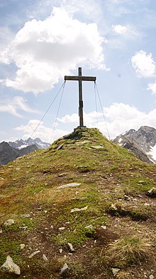
Summit cross on the Hennekopf |
||
| height | 2704 m above sea level A. | |
| location | Tyrol , Austria | |
| Mountains | Silvretta | |
| Dominance | 0.8 km → Hennespitze | |
| Coordinates | 46 ° 54 '34 " N , 10 ° 8' 22" E | |
|
|
||
| Normal way | Moderately difficult hiking trail (T2) from the Bieltal | |

The Hennekopf is 2704 m above sea level. A. (according to other information 2706 m above sea level ) high mountain in the Silvretta , which is located in the municipality of Galtür ( Tyrol ). The summit of the mountain is easily accessible on foot via the Bielerhöhe and the Bieltal.
Location and surroundings
The Hennekopf is about 3.5 km as the crow flies east of the Bielerhöhe ( Vorarlberg , 2037 m above sea level ) and about 7.3 km from the center of Galtür. It is about 2.3 km as the crow flies to the west of the Hohen Rad ( 2934 m above sea level ), about 6.5 km to the southwestern Dreiländerspitze and about 7.5 km to Piz Buin . To the south is the Madlenerspitze ( 2969 m above sea level ), named after mountaineer Andreas Madlener , about 1.9 km away, and to the northwest, about 800 m away, the Hennespitze ( 2707 m above sea level ).
To the northeast of the Hennekopf is the Roßtal (with the Roßtalbach ), to the south is the valley of the White Bach , which descends from the Getschnerscharte , and to the southwest is the Bieltal (with the Bielbach, also called Bieltalbach). The streams flow into the Trisanna . Usually only residual water flows from the Weißen Bach and the Bieltalbach into the Trisanna, since a large part of the water is collected and diverted into the Silvrettasee .
The Hennekopf is part of a long ridge that runs between Roßtalbach and Weißen Bach from up to 2931 m. ü. A.Template: height / unknown reference high Hennebergspitzen to the northwest to the Hennespitze, which towers prominently above the Bielerhöhe.
summit
The Hennekopf is largely easy to reach from the north-western side and drops steeply on all other sides. On it is a simple wooden summit cross , which was erected in 1993 by the Silvretta group of the Lochau ski club (information board made of copper on the cross).
getting there
The starting point for tours to the Hennekopf in summer and winter is regularly the Bielerhöhe.
The Bielerhöhe can be reached on foot from Partenen ( 1051 m above sea level ) in around 3½ hours and from Galtür ( 1584 m above sea level ) in around 2½ hours. In summer, you can also drive to the Silvretta-Hochalpenstraße via the Montafon and from the Paznaun Valley to Bielerhöhe (toll is mandatory). You can take the train to Schruns (from the west, Vorarlberg) or Landeck (from the east, Tyrol) and then take the post bus to Bielerhöhe. In winter it is only possible to take the Vermuntbahn from Partenen to the mountain station and from there a minibus (tunnel taxi bus) through two tunnels to Bielerhöhe.
hike
The Hennekopf requires surefootedness, alpine equipment with good mountain boots. The closest hiking base is the Madlenerhaus on the Bielerhöhe ( 1986 m above sea level ) and the restaurants on the Bielerhöhe - Silvrettahaus and Hotel Piz Buin. Alpe Vermunt is only cultivated in summer. The way from the Bielerhöhe ( 2037 m above sea level ) to the Hennekopf is about 9 km and about 750 meters in altitude are overcome.
According to the SAC hiking scale, the ascent is classified as a medium-difficult mountain hiking trail (T2). The path can be mastered in about 3 hours and is sometimes only marked by cairns , which is why good orientation is required. In winter for snow tours, the ascent is considered to be less difficult ( SAC ski tour scale : WS). The departure of slab avalanches is possible.
Web links
Individual evidence
- ↑ a b Alpine Club Card No. 26 "Silvrettagruppe" (Skitourenkarte), 9th edition 2013, ISBN 978-3-928777-37-7 .
- ↑ TIRIS - Tyrolean spatial information system
- ↑ In some cases, the beginning of the Trisanna is only seen from the confluence of the Vermuntbach and the Jambach, and the upper part is called Bielbach or Bieltalbach until then.
- ↑ Weather, snow cover and avalanches in Tyrol in winter 2003/2004 ( page no longer available , search in web archives ) Info: The link was automatically marked as defective. Please check the link according to the instructions and then remove this notice. , P. 34.

