Henry's Fork (Snake River)
| Henry's Fork | ||
|
Henry's Fork near the Coffee Pot Rapids |
||
| Data | ||
| Water code | US : 383107 | |
| location | Fremont County , Madison County in Idaho (USA) | |
| River system | Columbia River | |
| Drain over | Snake River → Columbia River → Pacific Ocean | |
| origin | Henrys Lake 44 ° 29 ′ 34 ″ N , 111 ° 16 ′ 58 ″ W. |
|
| Source height | 1974 m | |
| muzzle |
Snake River Coordinates: 43 ° 45 ′ 40 " N , 111 ° 56 ′ 49" W 43 ° 45 ′ 40 " N , 111 ° 56 ′ 49" W. |
|
| Mouth height | 1463 m | |
| Height difference | 511 m | |
| Bottom slope | 2.5 ‰ | |
| length | 204 km | |
| Catchment area | 8320 km² | |
| Discharge at the Rexburg A Eo gauge : 7560 km² Location: 14 km above the mouth |
MQ 1910/2016 Mq 1910/2016 |
59 m³ / s 7.8 l / (s km²) |
| Left tributaries | Fall River , Teton River | |
| Reservoirs flowed through | Island Park Reservoir, Ashton Reservoir, Chester Dam | |
| Small towns | St. Anthony | |
|
Upper Mesa Falls |
||
|
Lower Mesa Falls |
||
The Henrys Fork is a right tributary of the Snake River in the east of the US state Idaho .
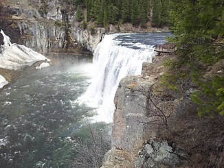
The river has its origin in the dammed and flow-regulated lake Henrys Lake. From there it flows mainly in a southerly direction through the mountains. It is dammed up on the upper reaches of the Island Lake Reservoir . The upper reaches of the river is within the Henrys Fork Caldera , which was formed 1.3 million years ago and has a diameter of 15 miles. The Henrys Fork breaks through the southern rim of the crater. There are the two waterfalls Upper Mesa Falls (35 m high, 61 m wide) and Lower Mesa Falls (20 m high) at a distance of almost 2 kilometers on the river. Above the Mesa Falls is Harriman State Park . The Henrys Fork later leaves the mountains and flows in a south-westerly direction past the small town of St. Anthony . Fall River and Teton River flow into it on the left. There are several dams on the river's lower course. Finally, the Henrys Fork flows into the Snake River 15 km southwest of Rexburg . The US Highway 20 runs in the area roughly the course of the River Henry's Fork. The Henrys Fork drains an area of 8320 km². The mean discharge not far from the mouth is 59 m³ / s.
The river is named after the fur trader Andrew Henry who explored the area in the early 19th century.
Both above and below the Mesa Falls, the river offers whitewater sections for canoeists, kayakers and rafting enthusiasts .


