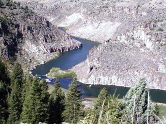
Teton River (Henry's Fork)
| Teton River | ||
| Data | ||
| Water code | US : 391950 | |
| location | Madison County , Fremont County , Teton County , Idaho (USA) | |
| River system | Columbia River | |
| Drain over | Henry's Fork → Snake River → Columbia River → Pacific Ocean | |
| Association of |
Warm Creek and Drake Creek 43 ° 36 ′ 57 " N , 111 ° 10 ′ 32" W. |
|
| Source height | 1839 m | |
| muzzle |
Henry's Fork Coordinates: 43 ° 53 ′ 56 " N , 111 ° 50 ′ 21" W 43 ° 53 ′ 56 " N , 111 ° 50 ′ 21" W |
|
| Mouth height | 1472 m | |
| Height difference | 367 m | |
| Bottom slope | 2.8 ‰ | |
| length | 132 km | |
| Catchment area | 2927 km² | |
| Discharge at the St. Anthony A Eo gauge : 2268 km² Location: 35 km above the mouth |
MQ 1934/2016 Mq 1934/2016 |
23.5 m³ / s 10.4 l / (s km²) |
| Small towns | Rexburg | |
The Teton River is a 132 km long left tributary of the Henrys Fork in the east of the US state Idaho .
The Teton River arises on the western slope of the Teton Range near Victor at the confluence of its source streams Warm Creek and Drake Creek . It initially flows 25 miles north before turning west. The Teton River cuts into the highlands. The Teton Dam was built between 1972 and 1975 on the Teton River, 12 km east-southeast of St. Anthony . On June 5, 1976, a dam broke . The downstream town of Rexburg was devastated. The dam was not renewed and now serves as a memorial. North of the village of Teton, the river splits into two arms. The northern arm ( Teton River or North Fork Teton River ) flows north past Sugar City and flows into Henrys Fork. The southern branch of the river ( South Fork Teton River ) runs along the northern edge of the town of Rexburg and also flows into the Henrys Fork.
