Hesperbach
| Hesperbach | ||
|
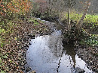
Natural course of the hesper |
||
| Data | ||
| Water code | DE : 276972 | |
| location | North Rhine-Westphalia , Germany | |
| River system | Dysentery | |
| Drain over | Ruhr → Rhine → North Sea | |
| source | Röttgen, Velbert 51 ° 20 ′ 38 ″ N , 7 ° 3 ′ 35 ″ E |
|
| Source height | 230 m above sea level | |
| muzzle | At Haus Scheppen in the Ruhr Coordinates: 51 ° 23 '51 " N , 7 ° 2' 58" E 51 ° 23 '51 " N , 7 ° 2' 58" E |
|
| Mouth height | 70 m above sea level NN | |
| Height difference | 160 m | |
| Bottom slope | 21 ‰ | |
| length | 7.7 km | |
| Catchment area | 17.89 km² | |
| Discharge at the Essen-Pörtingsiepen gauge, formerly Essen-Hespertal Location: 180 km above the mouth |
NNQ MNQ 1989/2009 MQ 1989/2009 MHQ 1989/2009 HHQ |
9 l / s , 033 271 l / s 5.44 m³ / s 15.2 m³ / s |
| Big cities | eat | |
| Medium-sized cities | Velbert | |
The Hesperbach is a geographically left-hand tributary of the Ruhr in North Rhine-Westphalia , Germany .
geography
The Hesperbach rises about 230 meters above sea level in the northern Velbert city area in the Langenhorst district. After a distance of 7.7 kilometers, it flows into the Ruhr near Haus Scheppen in the Fischlaken district of Essen . After its source on the edge of a garbage dump in Velbert, the young brook passes a few yards until it reaches three larger rainwater retention basins. Shortly afterwards it joins some tributaries and flows further north to join the largest tributaries here. Now the brook passes the city limits of Essen where it reaches its middle course. The Hesperbach has been greatly widened and cleared here by the tributaries. Due to the largely natural stream bed of its middle course, it has many characteristics of a low mountain stream, including an occurrence of the kingfisher and the dipper . After leaving the woods behind, the stream flows past some farms and listed factories again. These offer a testimony to the small industry in Lower Berg. Now the stream goes over into the lower course and flows around some restaurants and bars to dive into the woods again. After a few kilometers, it leaves the swampy forests of its lower reaches behind and flows through the site of the former Pörtingsiepen colliery . The Hespertal Railway ran from the former colliery on the eastern bank of the stream to its confluence with Haus Scheppen in the Ruhr, or the Baldeneysee . This section of the route was closed in 1973 and is now used as a hiking trail.
etymology
Leithäuser confirms Förstermann's assumption that the name Hesperbach means Waldbach . The earliest documented mentions of the brook were hesepe (827) and hesapa (841). The old Germanic -apa (= water, brook) can be found in these early names , as it is often found in derived forms in the water names of the region. The old Germanic word stem Hês means forest, Hesapa , Hesper means forest stream. Hesper-Bach with its suffix Bach represents a later double form, since Hesper alone has the meaning of forest brook .
Hydropower
Numerous mills and hammer mills have been in operation on the Hesper for centuries. The Hesper is one of the oldest industrial areas in Germany. Their surroundings were one of the earliest mining areas for Ruhr coal.
nature
On the middle and lower reaches of the Hesperbach there are numerous forests and meadows, most of which are designated as a landscape conservation area, in which rare species such as kingfisher , dipper and Roman snail also occur. The lower course with hiking trails serves as a local recreation area.
See also
Web links
Individual evidence
- ↑ a b TIM-online NRW - Topographical Information Management , accessed on December 3, 2011
- ↑ a b Gewaesserverzeichnis NRW ( MS Excel ; 4.8 MB), accessed on December 2, 2011
- ↑ Landesbetrieb Information und Technik NRW ( page no longer available , search in web archives ) Info: The link was automatically marked as defective. Please check the link according to the instructions and then remove this notice. , accessed December 2, 2011
- ^ Julius Leithäuser : place names in the Wupper area . Journal of the Bergisches Geschichtsverein , Volume 34, 1898

