Hirschbach (Ostrach)
| Hirschbach | ||
|
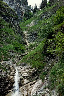
Waterfalls in the Hirschbachtobel |
||
| Data | ||
| Water code | DE : 114452 | |
| location | District of Oberallgäu | |
| River system | Danube | |
| Drain over | Ostrach → Iller → Danube → Black Sea | |
| source | Am Spieser 47 ° 31 '42 " N , 10 ° 22' 53" E |
|
| muzzle | Southwest of Bad Hindelang in the Ostrach 47 ° 30 ′ 10 ″ N , 10 ° 21 ′ 28 ″ E |
|
| Mouth height | approx. 815 m above sea level NHN
|
|
| length | 5.3 km | |
| Catchment area | 9.52 km² | |
| Left tributaries | Wildbach (Hirschbach) | |
The Hirschbach is a stream flowing towards the Ostrach in the Oberallgäu municipality of Bad Hindelang in Bavaria.
The Hirschbach rises in several source streams north of the Spieser in the northern Allgäu Alps . It flows east of the Hirschberg to the south. From the Kräherwand it flows through the steep Hirschbachtobel 400 meters down into the Ostrachtal. There it partially forms the border between the two districts of Bad Hindelang and Bad Oberdorf . Shortly before its mouth, the torrent flows into the deer park forest from the left .
Individual evidence
- ^ Bavarian Office for the Environment: Directory of brook and river areas in Bavaria. Retrieved August 15, 2017 .
