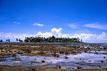
Hoa (tidal channel)


Hoa is a shallow channel that begins on the lagoon side of an atoll and separates two of the often numerous reef islands ( motus ). The water exchange between the lagoon and the open ocean takes place via Hoa , without which - due to the strong evaporation in tropical waters - the salt content in the lagoon would accumulate. "Hoa" is a Polynesian term that has now also found its way into modern scientific publications.
Emergence
The phenomenon of the Hoa is to be seen in close connection with the formation of the atolls, as already described by Charles Darwin . Atolls develop from high volcanic islands that are surrounded by a fringing reef. Due to tectonic processes and / or erosion, the central island sinks further and further, until finally only a closed ring of islands, which sit on the coral reef , rises above sea level. An example of such a development stage is the Rangiroa Atoll .
The formation of the Hoa is believed to be related to the devastation caused by cyclones and tsunamis on the low reef islands. The shallow atolls of the South Pacific are regularly washed over by strong winds. In the reef rim, which is only a few meters high, the surge of water can create gullies or cracks in which water flows into and out of the lagoon at ebb and flow. The constant flow of water widens and deepens the channels so that permanent breakthroughs emerge over time, which ensure a regular exchange of water between the lagoon and the open ocean. This allows the salt content of the lagoon to be equalized, despite the high evaporation rates, so that a rich underwater life within the reef rim is possible.
The phenomenon of the Hoa was first scientifically described by Alexander Agassiz , who made three research trips with the steamship Albatross to the Pacific between 1891 and 1904 . The Albatross , built in 1882, was a research vessel for the United States Fisheries Commission for hydrographic studies and for studying fish populations.
Classification
In 1960, before the start of the French atomic bomb tests in the South Pacific, the French geologist and paleontologist Jean-Pierre Chevalier examined the Mururoa atoll as a member of a scientific commission commissioned by the Direction des Centres d'Expérimentation Nucléaire (DIRCEN). Here and during further research in the Tuamotu Archipelago , he developed a general typology of the Hoa, which he divides into the following types based on their nature:
- Type 1: Channels that are open on the lagoon side but closed on the ocean side.
- Type 2: Channels that are open on both sides, including those that
- only at high tide,
- carry water even at low tide, but only when the waves are high
- others where continuous water flow is guaranteed.
- Type 3: Hoa, in which the lagoon side was subsequently closed by sediment accumulations.
- Type 4: Type 1 Hoa that were subsequently clogged with sediment and thus no longer carry water.
- Type 5: channels that have fallen completely dry (caused for example by seismic uplift). In some of them plants could settle over time.
- Type 6: Hoa open to the sea side, similar to type 3, but which are not closed by sediment but blocked by massive coral rock.
Closed channels can also be reactivated by cyclones, as was observed in the storms of 1983 on Mataiva.
Chevalier found that there is a correlation between wind strength, wind direction and the occurrence of Hoa. He dated most of the tidal channels to the Holocene and assumed formation in the last 3000 to 4000 years. Later investigations extended the time of origin to the last 6000 years.
Occurrence
Hoa can be found on most of the atolls of the Tuamotu Archipelago , for example: Rangiroa , Ahe , Mataiva , Puka Rua , but also on other islands in Polynesia, such as Bora Bora . The north side of Orona , Phoenix Islands , shows particularly many Hoa of most of the types described here.
literature
- David R. Stoddard & F. Raymond Fosberg: The Hoa of Hull Atoll and the Problem of Hoa, Atoll Research Bulletin No. 394, National Museum of Natural History, Smithsonian Institution , Washington DC, 1994
Individual evidence
- ^ Bengt Danielsson : Native topographical terms in Raroia, Tuamotus. Atoll Research Bulletin No. 32, Washington, DC, 1954, p. 92
- ↑ a b F. G. Bourrouilh-Le Jan, J. & B. Talandier Salvat: Early diagenesis from 6,000 years ago and the geomorphology of atoll rims in the Tuamotu. In: Proceedings of the 5th International Coral Reef Congress from May 27 to June 1, 1985 in Tahiti, Volume 3
- Jump up ↑ Norman D. Newell: Geological reconnaissance of Raroia (Kon-Tiki) Atoll, Tuamotu Archipelago , Bulletin of the American Museum of Natural History, Volume 109, No. 3, 1956
- ↑ Alexander Agassiz: Explorations of the "Albatross" in the Pacific Ocean, American Journal of Science , No. 4, 1900
- ^ Jean-Pierre Chevalier: Observations sur les chenaux incomplets appelés hoa dans les atolls de Tuamotu , Marine Biological Association of India: Proceedings of the Symposium on Corals and Coral Reefs 1972
- ↑ PA Pirazzoli & LF Montaggioni: Holocene sea-level changes in French Polynesia, in: Palaeogeography, Palaeoclimatology, Palaeoecology, Volume 68, December 1988, pp. 153-175
