
Bora Bora
| Bora Bora | ||
|---|---|---|
 |
||
| Waters | Pacific Ocean | |
| archipelago | Society Islands | |
| Geographical location | 16 ° 30 ′ S , 151 ° 45 ′ W | |
|
||
| Number of islands | approx. 30 | |
| Main island | Bora Bora | |
| Land area | 29.3 km² | |
| Highest elevation |
Mont Otemanu 727 m |
|
| Residents | 10,605 (2017) | |
 |
||

Bora Bora is an atoll that belongs to the group of Society Islands in French Polynesia , more precisely to the Leeward Islands in the South Pacific . The atoll is about 260 km northwest of Tahiti at 151 ° 44 'West and 16 ° 29' South and has a total land area of 38 km². Bora Bora is one of the most exclusive and luxurious vacation spots in the upper price range and is one of the most expensive travel destinations in the world.
Geology and geography


Bora Bora is an atoll that shows the classic atoll shape described by Charles Darwin with a central mountain and a coral fringe with numerous overlying motu . The formation of the atoll is so advanced that the caldera of the central volcano has already sunk. Only parts of the already largely weathered crater rim protrude above sea level, including the highest elevations on the island: Mont Otemanu with 727 m, Mont Pahia with 661 m and Mataihua with 314 m.
The central island of Bora Boras consists mainly of basaltic lava . Motu Toopua in the west is another remnant of the former crater rim that rises up to 148 m above the sea surface and also consists of volcanic rocks. The smaller motu are flat , sandy coral islands separated by tidal channels ( hoa ).
The elongated main island is 9 km long and 5 km wide at its widest point. The settlements are located exclusively in the coastal areas, the lush interior of the island is largely undeveloped. A 32 km long, paved ring road opens up the coastal region, the settlements and the hotels. The interior of the island is only partially accessible with off-road vehicles.
Bora Bora has 10605 inhabitants (as of 2017). The largest settlement, Vaitape with around 4600 inhabitants, is located on the west side of the island, opposite the main passage into the lagoon , the Teavanui Pass, which is so deep that it can also be used by larger cruise ships . They lie in the lagoon in the roadstead - often several at the same time - because the Vaitape quay is only suitable for small ships and boats. Vaitape is a founding of the British missionary John Muggridge Orsmond (1788-1856) of the London Missionary Society . He came to Bora Bora from Tahiti in 1824 and had a church and then a pier, streets and houses and a mission school built out of coral rock. From this settlement called " Beulah " today's Vaitape developed. Other villages are Fa'anui, the former seat of the ruling family, in the northwest and Anau in the east. The distance (as the crow flies) to the Australian continent (Sydney) is 5983 kilometers, to Hawaii (Honolulu) it is 4230 kilometers.
history
According to recent research, the Society Islands were settled relatively early as part of the Polynesian expansion, around 200 BC. BC, starting from Samoa and Tonga and around the same time as the settlement of the Marquesas . Together with the Marquesas, they formed the Polynesian heartland and thus the springboard for colonization of Hawaii , New Zealand , the Gambier Islands and possibly Easter Island .
On Bora Bora - as on the other Society Islands - a stratified tribal society developed, which was divided into eight districts, the cause of constant rivalries and wars between the tribes. The eight tribes were (clockwise from north to south): Hitiaa, Tipoto, Anau, Atitia, Amanahune (Fa'anui), Nunue and Tevaitapu on the main island and Ativahia on the great Motu Tooupua in the west. The three sub-communities ( Communes associées ) Anau, Fa'anui and Nunue remain as today's political structure .
Outward signs of a very warlike society are two fortresses on the Pahia, the remains of which are still visible today. They consisted of a sophisticated system of earth and stone walls, trenches and platforms. The missionary and explorer Daniel Tyerman describes the facilities that were still intact in the first half of the 19th century:
“That morning we visited two 'Pari', as the natives call them, on the high mountain of Pahia. These were rough fortifications on the last accessible slopes of the mountain. They enclosed a considerable area, divided by strong walls, which not only acted as demarcations, but were armed with ammunition to repel enemies climbing up. They were separated by footpaths and stretched along a rocky ridge. Each fortress is 800 m long and consists of rough but effective fortifications, best adapted to the environment and the type of warfare of the natives. In the area there are breadfruit, coconut palms, bananas and other fruit-bearing trees as well as water sources, so that a garrison under siege was able to withstand for months. It must have been very difficult for the attackers to get them to give up or to storm the fortress. "
Numerous relics of the Polynesian natives of Bora Bora are still preserved today: Remains of 13 ceremonial platforms ( marae ) - once there were more than forty - and many petroglyphs , which are mostly hidden in inaccessible bushes. The best preserved ceremonial site is the Marae Fare Opu in Faʻanui Bay, located directly on the beach. Today the road leads through the area, so that the overview of the quite large square was lost. The facility once consisted of a rectangular, leveled area delimited with stones and a stone platform. The rectangular platform is bordered with limestone slabs more than 1 m high and filled with earth. Two of the panels on the north side are carved in stone with turtle motifs.
The first European to see Bora Bora was likely James Cook , who cruised between the Society Islands after observing the transit of Venus during his first voyage in 1769. On July 29, 1769, the Endeavor approached the island - Cook called it "Bolabola" - to within 2 to 3 miles. Due to adverse winds, however, he had to turn away. The next day he did not reach the island either and only circumnavigated its southern tip outside the fringing reef before the ship sailed west towards Maupiti . Cook did not enter Bora Bora until his third voyage in 1777.
Other sources refer to the explorer as the British Samuel Wallis , who crossed the group of Society Islands during his circumnavigation of the world in 1767. He sailed from Tahiti on July 26, 1767, past Moorea , Maiao , Mopelia and Manuae into the Tonga archipelago. It is doubtful whether he touched Bora Bora in the process; his records do not allow any clear conclusions. He did not set foot on the island.
It is unclear whether the Dutchman Jakob Roggeveen saw Bora Bora during his circumnavigation in 1722, as some authors suspect. Neither his notes nor the travelogue of Carl Friedrich Behrens clearly show this. Roggeveen was probably driving north past the Society Islands.
On April 2, 1768, the French explorer Louis Antoine de Bougainville reached Tahiti, took possession of the Society Islands for France and thus founded what is now French Polynesia .
However, this step initially had no consequences, because until the middle of the 19th century Bora Bora - like the other Society Islands - continued to belong to the sphere of influence of the Pomaré royal dynasty of Tahiti. After Queen Pomaré Vahine IV of Tahiti had to give in to the demands of Rear Admiral Abel Aubert Dupetit-Thouars , who was sent from France, and had to recognize the French protectorate over her domain, her son and successor Arijane, who as Pomaré V only led a sham government, renounced . 1880 to any claim to the throne. As a result, the Society Islands were annexed by France and became a French colony .
During the Second World War , after the attack on Pearl Harbor on December 7, 1941 , Bora Bora became an important US supply base in the South Pacific. Under the code name "Operation Bobcat", a fleet of six troop transports and supply ships of the US Navy departed from Charleston (South Carolina) on January 27, 1942 and landed a total of 4,400 soldiers, including an engineer battalion and an anti-aircraft regiment, on Bora on February 17, 1942 Bora on. Unloading the equipment that was carried along took 52 days, as no loading and unloading facilities were available on the island and had to be built first. The US military built a tank farm, a runway and a base for seaplanes. Several strategically important areas were secured with coastal batteries and anti-aircraft cannons . Some of the rusted cannons can still be seen today. However, the US base was not attacked during the war and abandoned in 1946.
flora
The relatively densely populated and intensively used flat regions for a Polynesian atoll hardly contain any remains of the original vegetation. The flora of the high and steep mountains, which are difficult to access, is largely untouched.
The rear areas of the beach are lined with low, bushy Cordia subcordata and Hibiscus tiliaceus . A cultivated form, Hibiscus tiliaceus var. Sterilis , with a straight trunk and a nicely rounded crown, is often planted as a roadside green.
Up to the foot of the steep mountain region there is mainly cultivated land with coconut plantations, breadfruit trees , Tahitian chestnuts ( inocarpus ), cassava ( manihot ), tropical fruits and orchid plantations for decoration in the tourist hotels. Abandoned areas have been conquered by overgrown guavas and the fern Dicranopteris linearis .
The crevices and ridges of the island mountains are overgrown with largely undisturbed remains of the original island vegetation. These include Metrosideros -Haine, stocks of Wikstroemia coriacea , an endemic species of the family in Polynesia Thymelaeaceae , and some types of Glochidion . The damp and shady crevices are densely populated with ferns.
Politics and administration
Politically, Bora Bora is now part of French Polynesia. The island is French overseas territory , but not part of the EU . It is administered by a subdivision ( Subdivision administrative des Îles sous le Vent ) of the High Commission of French Polynesia ( Haut-commissariat de la République en Polynésie française ) based in Papeete. Bora Bora is one of seven municipalities of the subdivision administrative des Îles sous le Vent , which in turn is subdivided into the three sub-municipalities ( Communes associées ) Nunue, Fa'anui (plus the Tupai atoll further north) and Anau. The local administration is located in Vaitape.
The official language is French. The currency is the CFP franc linked to the euro .
Infrastructure and tourism

The island's economy is now based almost exclusively on tourism . Along with Tahiti, Bora Bora is likely to be one of the best developed islands in the South Pacific for tourism. There are numerous hotels, mainly of the upper and highest price range, which are mainly visited by Americans and Japanese. The price level is exorbitantly high, Bora Bora is one of the most expensive travel destinations in the world with daily prices in the high three-digit euro range. Several luxury hotels are located on the motus of the fringing reef and offer so-called overwater bungalows that are built into the lagoon on stilts. Through a glass table top you can watch the colorful coral fish at breakfast, which is brought in outrigger canoes. Bora Bora is now often called at by cruise ships, often as part of their world circumnavigation. The ships mostly go into the deep water off Vaitape, because the small harbor quay is not suitable for this. The passengers are brought ashore and ensure that the otherwise peaceful island life is enlivened for a few hours.
A public bus ( Le Truck ) operates on the main island and takes around an hour to drive around the island on the ring road. There are no stops, the bus stops where the passengers want it. However, the preferred means of transport for tourists are bicycles and mopeds or scooters and the shuttle service that some hotels offer. You can rent small electric cars in Vaitape. A private helicopter is stationed on the island for sightseeing flights.
The Bora Bora airport is a former military airfield of the US Air Force , which is served by local Polynesian Airlines today. It is located on the Motu Mute in the north of the atoll. Air passengers are brought to their hotels by boat over a journey of up to three hours. The flight from Tahiti to Bora Bora with small propeller planes takes about 45 minutes.
The main town and seat of the local administrative authorities is Vaitape. The place has a few small supermarkets, banks, post offices, a Catholic church, a school and a gendarmerie station and otherwise has no special sights.
Attractions

The main attraction on Bora Bora is the lagoon with its largely intact underwater world. With the glass bottom boat , while diving and snorkeling , you can explore the reef with thousands of colorful coral fish. In the deep lagoon there are barracudas and sharks that can be fed during guided diving tours. A world-famous attraction for divers is the "Roche Road", an area in the lagoon, where various species of skates occur in large schools, including many manta rays and leopard stingrays .
Parts of the interior of the island can be explored with jeep safaris. However, the natural beauties of the island can be better explored on foot. You can go on several hikes from Vaitape, but you should trust a guide so as not to get lost. The hike to the summit of Pahia, from which legend has it that Oro, the god of war, descended on a rainbow , leads through orchards, forests, orchid fields and fern-covered crevices. You can also climb Mount Otemanu, which offers a beautiful panoramic view of the atoll. Below the summit is a spacious grotto where numerous frigate birds nest.
The remains of more than 40 marae (ceremonial platforms) are worth seeing. The best preserved are the Marae Fare Opu in Faanui Bay and the Marae Aehau-tai or Temaruteaoa in the far east in Vairau Bay. Another large ceremonial site of the indigenous people is the Marae Marotitini in the north of the main island, directly on the beach. The complex's stone platform was originally 42 meters long and was restored in 1968 by Japanese archaeologist Yosihiko Sinoto. Two stone box graves belonging to the royal family were found in the area of the complex.
The most beautiful beaches (and numerous hotels) are located in the two large bays between Pointe Paopao and Pointe Matira in the southwest of the island and on the opposite Motus. About five kilometers south of Vaitape, right on the main street, is Bloody Mary’s , a world-famous bar with a restaurant and its own jetty for yachts, where numerous prominent guests frequent. 230 names are recorded on two wooden plaques at the entrance, including a. Marlon Brando, Jane Fonda, Diana Ross.
Others
- In 1931 Friedrich Wilhelm Murnau shot his famous silent film Tabu , a mixture of documentary and feature film with local amateur actors , on the Motu Tapu next to the Teavanui Passage, which in earlier times was reserved exclusively for the royal family .
- Bora Bora is also the title of an Italian erotic film shot in 1968, see Bora Bora (1968) .
- In 1978 Jan Troell shot the disaster film Hurricane on Bora Bora (producer: Dino de Laurentiis ), for which a splendid colonial-style villa was specially built on the southern edge of Vaitape.
- The singer Tony Marshall became an honorary citizen of Bora Bora on February 16, 2008. He had a chart success with the song of the same name in 1978 and made the island known in Germany. The residents therefore approached him and offered him honorary citizenship for the 30th anniversary of the song.
- Most of the film All Inclusive was shot on Bora Bora.
- The German game author Stefan Feld brought out the board game Bora Bora in 2013 .
- photos
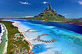
Bora Bora aerial view
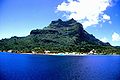
Vaitape

Faanui

Marae Fare Opu

Turtle motif on the Marae Fare Opu


Web links
Individual evidence
- ^ Christian Nau: Dictionnaire des Îles, Paris 2002.
- ^ Institut Statistique de Polynésie Française (ISPF) - Recensement de la population 2012.
- ^ William Ellis: Polynesian researches, during a residence of nearly six years in the South Sea Islands , Volume 2, London 1829, p. 553.
- ^ Patrick V. Kirch: On the Road of the Wind - An Archaeological History of the Pacific Islands Before European Contact '. Berkley-Los Angeles-London 2000, p. 231.
- ↑ James Montgomery: Journal of the Voyages and Travels by the Rev. Daniel Tyerman and George Bennet Deputed from the London Missionary Society, to Visit their Various Stations in the South Sea Islands, China, India & c, Between the Years 1821 and 1829. Volume 2, Boston / New York 1832, p. 168.
- ↑ Kenneth P. Emory: Stone Remains in the Society Islands. New York 1971, pp. 160-167.
- ↑ Max Quanchi, John Robson: Historical Dictionary of the Discovery and Exploration of the Pacific Islands. Lanham / Toronto / Oxford 2005.
- ↑ JC Beaglehole: The Journals of Captain James Cook on his Voyages of Discovery. Cambridge 1968, Volume 1, pp. 146-147.
- ^ John Hawkesworth: An Account of the Voyages Undertaken by the Order of His Present Majesty for Making Discoveries in the Southern Hemisphere, and successively performed by Commodore Byron, Captain Carteret, Captain Wallis, and Captain Cook. London 1783, Volume 1, pp. 492-493.
- ^ John Dunmore: Who's who in Pacific Navigation. Honolulu 1991, p. 211.
- ↑ Johannes van Braam (ed.): Tweejaarige reyze rondom de wereld, ter nader ontdekkinge der onbekende zuydlanden, met drie schepen, in het jaar 1721, door last van de Nederlandsche Westindische Maatschappy. Dortrecht 1728 (report on Roggeveen's world tour, probably by Roggeveen himself or according to his information).
- ^ Karl Friedrich Behrens: The well-attempted southerner - trip around the world 1721/22. Brockhaus, Leipzig 1923 (reprint).
- ^ Duncan S. Ballantine: US Naval Logistics in the Second World War. Naval War College Press, Newport 1998, p. 67 f.
- ^ Peter Mueller-Dombois & Raymond Fosberg: Vegetation of the Tropical Pacific Islands , New York 1998, pp. 428-429.
- ↑ Cosima Schmitt: And of course the women! , Die Zeit on February 2, 2008, accessed on September 16, 2013