Mehetia
| Mehetia | ||
|---|---|---|
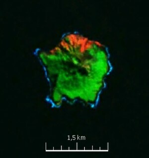
| Satellite image: NASA Geocover 2000 | ||
| Waters | Pacific Ocean | |
| Archipelago | Society Islands | |
| Geographical location | 17 ° 52 ′ 30 ″ S , 148 ° 4 ′ 3 ″ W | |
|
|
||
| length | 1.7 km | |
| width | 1.7 km | |
| surface | 2.28 km² | |
| Highest elevation | Mont Fareura 435 m |
|
| Residents | uninhabited | |
|
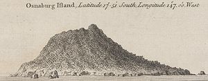
Mehetia, in 1769 seen from the west |
||
Mehetia or Meetia (old Polynesian name: Meetu , old European names: Osnaburgh, Boudoir, San Cristobal ) is an uninhabited volcanic island in the southern Pacific Ocean , which geographically belongs to the Society Islands and politically to French Polynesia .
Geography and geology
Mehetia is 110 km east of Tahiti and is the most easterly of the " Leeward Islands " (French Îles du Vent). The land area is 2.28 km², the highest point is Mt. Fareura, which reaches up to 435 m and is still an active stratovolcano . The island belongs to the Teahitia-Mehetia hotspot and consists mainly of basaltic rocks. It rises steeply from the sea floor from a depth of 4000 m and is geologically quite young, around 30,000 to 550,000 years old.
The summit of Mt. Fareura has an 80 m deep, now overgrown crater with a diameter of 150 m on the northwest side . From this crater, a lava field faces the sea, the result of recent eruptions . Polynesian legends tell of a "great fire" on the island. The geological findings agree with this legend and suggest an eruption within the last 2000 years.
In 1981 and 1983 there were seismic activities in the area of Mehetia, which led to numerous earthquakes up to a maximum strength of 4.3 on the Richter scale .
In the south of Mehetia, steep cliffs up to 40 m high protrude directly from the sea, the other coastal areas were also gnawed by the sea and are heavily eroded. A protective coral reef and a coastal plain are missing, only in the north does the island rise a little more gently. Landing is difficult because of the steep coast and the mostly heavy surf.
Flora and fauna
The flora is relatively poor in species and includes fewer than 100 species. The youngest lava field in the north and the summit region of Mt. Fareura are arid and hardly overgrown. The remaining areas of the island are covered by a dense secondary forest, which is mainly composed of Hibiscus tilliaceus , Casuarina equisetifolia and various Pisonia and Ficus species. In some areas, especially in the south, you can also find the grass Miscanthus floridulus , and occasionally there are coconut palms.
According to information provided by residents of the neighboring island of Tahiti, the now extinct red-billed rail ( Gallirallus pacificus ) may have once lived on Mehetia. There are said to have been sightings back in the 1920s.
history
Little is known about the Polynesian natives. However, the island lies on an ancient Polynesian trade route between the Society Islands and the Tuamotu Archipelago . From the Tuamotu Islands, pearls and oyster shells were imported for making the fish hooks, and stone tools were exported by Mehetia. Mehetia stone adzes and breadfruit masons have been found on some Tuamotu Islands. As with the Tuamotus, there seem to have been close contacts with Tahiti. British Captain James Wilson reports that Chief Tiaraboo has claimed Mehetia from the Taiarapu Peninsula on Tahiti-Iti. Contact was maintained by a large war canoe that ran between the two islands once or twice a year. Accordingly, Mehtia was permanently inhabited, but does not seem to have been divided into several tribal districts.
The only archaeological investigation, an exploration of the surface, was carried out by the American anthropologist Kenneth P. Emory from December 13-16, 1930. At that time there were still two Polynesian families living on the island. Emory found the remains of six smaller ceremonial sites ( marae ) and some stone platforms for Native Polynesian people. The ruins, the age of which is unknown, were all on the south coast. Emory was able to recover 10 stone breadfruit pounders and 28 adzes as surface finds. The finds are now in the warehouse of the Bernice P. Bishop Museum on Oahu .
The island was discovered for Europe on June 18, 1767 by Samuel Wallis , who called it "Osnaburgh", after Friedrich August, Duke of York and Albany , the second son of King George III. (United Kingdom) and last Prince-Bishop of the Osnabrück Monastery . Wallis, under the command of Lieutenant Tobias Furneaux, sent out a boat manned by armed men to prepare for a landing. Furneaux was unable to find an anchorage for the HMS Dolphin or a suitable landing facility for boats. During the exploration, several canoes with islanders approached and there was a peaceful exchange of gifts. The boat of Dolphin came close to the shore and the crew threw a rope to the standing there, men and women. However, it was not possible to go ashore. Furneaux saw about a hundred Polynesians and a few double canoes at the landing site. It seemed to him to be more people than the small island could have fed. According to Valais records, it is not possible to determine with certainty whether the residents were permanent residents or only temporarily present.
Occasionally, it is also claimed that Mehetia is identical to the island "La Decena" mentioned by Quirós. It would have been discovered by Pedro Fernández de Quirós as early as 1606 . However, the thesis is not tenable and has already been challenged by James Cook . Cook passed Mehetia in April 1769 during his first voyage and on August 13, 1773 during his second voyage to the Pacific. He describes it as a high, round island, rocky and only partially covered with trees. He does not provide any information about any residents. Cook did not go ashore, but sailed on to Tahiti without delay.
On April 2, 1768 drove Louis Antoine de Bougainville on the island over and called it "Le Boudoir" and Mt. Fareura after his ship "Pic de la Boudeuse". Bougainville did not go ashore, but thought it was the first to discover it.
On September 26, 1772, Domingo de Boenechea set sail with the ships Aguila and Jupiter from Callao to annex Tahiti for the Spanish crown. On November 13, 1774, at 9:00 in the morning, the ships reached the island of Mehetia, which Boenechea named "San Cristobal". Some canoes with islanders moored at the Aguila and there was an exchange of gifts. The vice-captain Thomas de Gayangos was able to find out through the interpreter Pautu that the inhabitants of Mehetia were closely connected with the tribes of Tahiti. At that time, as Gayangos reports, there were six Tahitians on Mehetia.
The island, which is no longer permanently inhabited, belongs politically to French Polynesia and is administered by the municipality of Taiarapu-Est , sub-municipality ( Commune associée ) Tautira, on Tahiti. Mehetia is private property.
Individual evidence
- ↑ V. Clouard and A. Bonneville: Ages of seamounts, islands and plateaus on the Pacific plate , Paris 2004, p. 28
- ↑ Jacques Talandier and Emile A. Okal: The volcanoseismic swarms of 1981-1983 in the Tahiti Mehetia area, French Polynesia , Journal of Geophysical Research, Volume 89, Issue B13, p 11,216 to 11,234.
- ^ Dieter Mueller-Dombois, Raymond Fosberg: Vegetation of the Tropical Pacific Islands , New York 1998, pp. 413-414.
- ↑ Barry Taylor: Rails: A guide to the rails, crakes, gallinules and coots of the world, New Haven, 1998.
- ↑ Kenneth P. Emory: Stone Remains in the Society Islands , Honolulu 1971, p. 110.
- ↑ James Wilson: A missionary voyage to the southern Pacific ocean, Performed in the years 1796, 1797, 1798, in the ship Duff, Commanded by Captain James Wilson, London 1799th
- ^ Paul Wallin: Ceremonial Stone Structures - The Archeology and Ethnohistory of the Marae Complex in the Society Islands, French Polynesia , Uppsala 1993, p. 119.
- ↑ Kenneth P. Emory: Stone Remains in the Society Islands , Honolulu 1971, pp. 109-119.
- ^ John Hawkesworth: An Account of the Voyages undertaken by the order of His Present Majesty for making Discoveries in the Southern Hemisphere, and successively performed by Commodore Byron, Captain Wallis, Captain Carteret and Captain Cook, in the Dolphin, the Swallow, and the Endeavor , London 1773, pp. 172-173.
- ↑ JC Beaglehole: The Life of Captain James Cook, London 1974
- ^ Peter Henry Buck (Te Rangi Hiroa): Vikings of the Sunrise , New York 1938
- ↑ Max Quanchi and John Robson: Historical Dictionary of the Discovery and Exploration of the Pacific Islands, Lanham (MD) of 2005.
- ↑ Bolton G. Corney: The quest and occupation of Tahiti by the emissaries of Spain in 1772-1776 , London 1913, pp. 116-117.
- ↑ James R. Mancham: Island Splendor - dream islands all private , Hamburg 1980
Web links
- Mehetia the Global Volcanism Program of the Smithsonian Institution (English)
- French Polynesia Government Presidency (2003): Mehetia
- Helicopter flight over Tupai (Youtube video from 2013, 5:35 min.)


