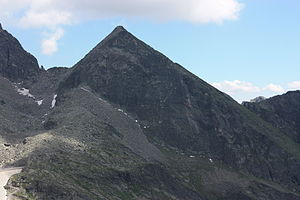
Hochkedl
| Hochkedl | ||
|---|---|---|
|
The summit of the Hochkedl from the east |
||
| height | 2558 m above sea level A. | |
| location | Carinthia , Austria | |
| Mountains | Reisseckgruppe , Ankogelgruppe | |
| Dominance | 0.3 km → Little Lyre | |
| Notch height | 158 m ↓ Seescharte | |
| Coordinates | 46 ° 54 '34 " N , 13 ° 22' 37" E | |
|
|
||
| rock | Granite , orthogneiss | |
| Normal way | from the Hotel Reißeck via the Reißeckhütte and the Seescharte | |
The Hochkedl is 2558 m above sea level. A. high mountain of the Reisseck group in the Hohe Tauern . The summit is located on the municipal boundary between Mühldorf and Lurnfeld . The 2400 m high Seescharte separates the Hochkedl from the 2662 m high Kleine Leier in the northeast, and the 2336 m high Staffenhöhe in the southwest . In a north-westerly direction lies the Reisseck lake plateau with the reservoirs Großer and Kleiner Mühldorfer See. In a south-easterly direction you get to the Hochkar "Im Goaßele".
tourism
The summit is easy to reach thanks to the development of the area with the Reißeckbahn or the Reißeck-Höhenbahn . From the mountain station of the Höhenbahn and the neighboring mountain hotel Reißeck ( 2287 m ) it takes 15 minutes to the Reißeckhütte ( 2287 m ) and from there to the summit in one hour. The tour is considered easy, the few difficult parts are secured with steel cables. However, children up to ten years of age should be kept on a short rope.

