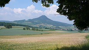
Hohenhewen
| Hohenhewen | ||
|---|---|---|
|
Hohenhewen from the south |
||
| height | 845.3 m above sea level NHN | |
| location | Baden-Wuerttemberg , Germany | |
| Mountains | Hegau | |
| Coordinates | 47 ° 50 '8 " N , 8 ° 44' 50" E | |
|
|
||
| Type | Kegelberg | |
| rock | basalt | |
| particularities | Hohenhewen castle ruins with viewing platform | |
|
Hohenhewen from the southeast |
||
The Hohenhewen , also called Hohenhöwen or colloquially Höwen , is the local mountain of the town of Engen im Hegau .
Summit area
The summit of the Hohenhewen is 845.3 m above sea level. NHN , with which it towers over its immediate surroundings by around 300 meters. On its summit plateau are the Hohenhewen castle ruins and a viewing platform attached to the rest of the keep, from which you can see the other Hegauberge mountains , Lake Constance and the Swabian Alb to the north, as well as the Alps and the Black Forest on a clear day.
Approaches
The Hohenhewen can be climbed on the north side from Anselfingen and on the south side from Welschingen . While the north ascent is still reasonably wide and comfortable ( T1 ), the ascent from Welschingen is much steeper and narrower and requires a certain degree of surefootedness (T2). Sturdy shoes are recommended.
Geology and conservation
Like almost all Hegauberge mountains, the Hohenhewen is of volcanic origin: Its subsoil consists of basalt . A 39 hectare part of the Hohenhewen has been designated as a nature reserve since 1982. The overdivided eastern flank is of particular botanical interest.
See also
Web links
- Profile of the nature reserve in the LUBW's list of protected areas
- Hohenhewen Castle on burgen-und-ruinen.de ( Memento from October 12, 2015 in the Internet Archive )


