Hollow mountain
| Hollow mountain | ||
|---|---|---|
|
The Hohle Berg seen from Engelhardsberg |
||
| height | 522.6 m above sea level NHN | |
| location | between Muggendorf and Engelhardsberg | |
| Mountains | Franconian Alb | |
| Coordinates | 49 ° 47 '59 " N , 11 ° 16' 37" E | |
|
|
||
| rock | limestone | |
| Age of the rock | law | |
| particularities | Cave-rich mountain, Hohes Kreuz observation tower | |
|
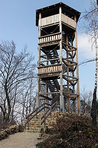
The observation tower on the Hohe Kreuz |
||
The Hohle Berg , also known as the Hohes Kreuz , is 522.6 m above sea level. NHN high mountain north of the Wiesent valley between the Wiesent Taler districts Muggendorf and Engelhardsberg . At the highest point of the mountain is a hexagonal steel-wood tower with a height of twelve meters, which was built in 2011 and inaugurated on April 15, 2011. This was built as a replacement for an older tower. There is also a cell phone mast near the summit.
The name of the mountain is derived from the numerous caves in the mountain. Significant caves are the Oswald Cave , Cave of Wonders , Doctor cave and joke cave . The Doktorshöhle is in the immediate vicinity of the summit.
Accesses
A road closed to public traffic as well as the Frankenweg (marking: red cross bar) and Heinrich-Uhl Weg (marking: red vertical line) lead to the summit of the Hohlen Berg .
Web links
Individual evidence
- ↑ Map services of the Federal Agency for Nature Conservation ( information )
- ↑ Hohes Kreuz inaugurated on fraenkische-schweiz.bayern-online.de


