Holmsland Klit
| Holmsland Klit | ||
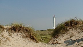
 Lyngvig lighthouse on Holmsland Klit |
||
| Geographical location | ||
|
|
||
| Coordinates | 55 ° 59 ′ N , 8 ° 8 ′ E | |
| Waters 1 | Ringkøbing Fjord | |
| Waters 2 | North Sea | |
| length | 30 km | |
| width | 2 km | |
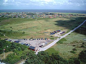
 View from the lighthouse over Nørre Lyngvig to Ringkøbing Fjord |
||
Holmsland Klit (dt. Holmsland dune) is a spit that separates the Ringkøbing Fjord in Danish Jutland from the North Sea . It is about 30 km long and up to 2 kilometers wide. At the northern end is the small town of Søndervig , in the south Nymindegab and in the middle section the port town of Hvide Sande . The settlements Bjerregård , Haurvig , Aargab , Lyngvig and Klegod are also on the spit . They have largely consisted of holiday homes since the 20th century.
The 38 m high Lyngvig Fyr lighthouse was built on a 17 m high brown dune and can be visited.
history
Before tourism flourished, the residents of the northern Holmsland drove their cattle across the spit in spring, where they spent the summer. As the population grew, the dune land was also populated by fishing small farmers. Potatoes and oats thrived on the barren soil, and their livelihood was supplemented by fishing. In the 19th century, two small churches were built in Lyngvig and Haurvig.
After the connection of the Ringkøbing Fjord to the sea had shifted ever further south from the 17th century and the lagoon threatened to become an inland lake, a penetration with two locks was made in the middle of the dune strip , a ship lock and a drainage lock . After the breakthrough was completed, the town of Hvide Sande was founded in 1931 , and its port is one of the most important fishing ports on the Danish North Sea coast.
Worth seeing
The lock system with a bascule bridge for road traffic is located in the center of the city of Hvide Sande.
The daily fish auction at the port at seven in the morning is of great tourist interest. The local fishing museum "Fiskeriets Hus" shows the regional marine fauna on approximately 400 m² of exhibition space .
Lyngvig Fyr lighthouse is located six kilometers north of Nørre Lyngvig . With a height of 38 m and a fire height of 53 m, it is one of the tallest lighthouses in Denmark. The lighthouse was automated in 1965.
To the south is the Abelines Gaard Museum . The typical regional farm from 1854 gives an impression of the living conditions on the spit in earlier times. In 1996, the museum was awarded the Europa Nostra Prize for outstanding achievements in the preservation of cultural heritage .
Haurvig Church is seven kilometers south of Hvide Sande. Erected as a chapel in 1869, it was renovated in 1947 and also received a church tower. In the cemetery there are graves and stones of soldiers of the Allied forces.
Web links
hvidesande.dk Tourist Information Hvide Sande and Holmsland Klit (German)
Individual evidence
- ↑ Stråtækt gård får pris. Retrieved March 9, 2011 (Danish).
