Honings
|
Honings
community Hetzles
Coordinates: 49 ° 38 ′ 17 ″ N , 11 ° 6 ′ 15 ″ E
|
|
|---|---|
| Height : | 358 (357-364) m above sea level NHN |
| Residents : | 87 (1987) |
| Postal code : | 91077 |
| Area code : | 09134 |
|
The Hetzleser district of Honings
|
|
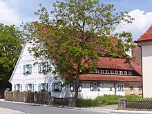
Honings is a Franconian village that belongs to the Hetzles .
geography
Located in Erlanger Albvorland located village is one of two officially designated community parts of the Upper Franconian municipality Hetzles. It is located about two kilometers west-northwest of the center of Hetzles at an altitude of 358 m above sea level. NHN .
history
Up until the beginning of the 19th century, Honings was under the sovereignty of the Bamberg Monastery. The authority of the village and community , which is decisive for this in the Franconian region , was exercised by the Neunkirchen office as bailiwick . The high jurisdiction was that office in his role as cents Office to.
When the Bamberg Monastery was secularized as a result of the Reichsdeputationshauptschluss 1802/03 and annexed by the Electorate of Palatinate-Baiern in breach of the Imperial Constitution , Honings became part of the New Bavarian territories that were forcibly taken over during the Napoleonic land consolidation .
As a result of the administrative reforms carried out in the Kingdom of Bavaria at the beginning of the 19th century , Honings became part of the independent rural community of Hetzles with the second community edict in 1818, which at that time also included the village of Baad , which was later re-communityed to Neunkirchen . In 1987 Honings had 87 inhabitants.
traffic
The state road St 2243 coming from Neunkirchen leads directly past the southwestern edge of the village and continues to Effeltrich . In addition, a community road connects the place with Hetzles. The village is served by public transport at a bus stop on bus line 224 of the VGN . The nearest train station is in Baiersdorf and is on the Nuremberg – Bamberg railway line .
Attractions
There are six listed buildings in and around Honings, including two farmhouses.
literature
- Ingomar Bog: Forchheim . In: Historical Atlas of Bavaria . Commission for Bavarian State History, Munich 1955.
- Gertrud Diepolder : Bavarian History Atlas . Ed .: Max Spindler . Bayerischer Schulbuch Verlag, Munich 1969, ISBN 3-7627-0723-5 .
- Johann Kaspar Bundschuh : Honings . In: Geographical Statistical-Topographical Lexicon of Franconia . tape 2 : El-H . Verlag der Stettinische Buchhandlung, Ulm 1800, DNB 790364298 , OCLC 833753081 , Sp. 758 ( digitized version ).
- Federal Statistical Office (Hrsg.): Historical municipality register for the Federal Republic of Germany. Name, border and key number changes in municipalities, counties and administrative districts from May 27, 1970 to December 31, 1982 . W. Kohlhammer, Stuttgart / Mainz 1983, ISBN 3-17-003263-1 .
Web links
- Bavarian official guide for honings , accessed on October 1, 2019
- Honings in the BayernAtlas , accessed on October 1, 2019
- Honings on a historical map , accessed October 1, 2019
- Honings in the Topographia Franconiae of the University of Würzburg , accessed on October 1, 2019.
Individual evidence
- ↑ a b Bavarian State Office for Statistics and Data Processing (Ed.): Official local directory for Bavaria, territorial status: May 25, 1987 . Issue 450 of the articles on Bavaria's statistics. Munich November 1991, DNB 94240937X , p. 302 ( digitized version ). Retrieved October 1, 2019
- ^ Honings in the local database of the Bayerische Landesbibliothek Online . Bayerische Staatsbibliothek, accessed on October 1, 2019.
- ↑ Geographical location of Honings in the BayernAtlas , accessed on October 1, 2019
- ↑ Gertrud Diepolder : Bavarian History Atlas . Ed .: Max Spindler . Bayerischer Schulbuch Verlag, Munich 1969, ISBN 3-7627-0723-5 , p. 31 .
- ↑ Gertrud Diepolder : Bavarian History Atlas . Ed .: Max Spindler . Bayerischer Schulbuch Verlag, Munich 1969, ISBN 3-7627-0723-5 , p. 97-103 .
- ^ Ingomar Bog: Forchheim . In: Historical Atlas of Bavaria . S. 61 .
- ^ Johann Kaspar Bundschuh : Honings . In: Geographical Statistical-Topographical Lexicon of Franconia . tape 2 : El-H . Verlag der Stettinische Buchhandlung, Ulm 1800, DNB 790364298 , OCLC 833753081 , Sp. 758 ( digitized version ).
- ↑ Gertrud Diepolder : Bavarian History Atlas . Ed .: Max Spindler . Bayerischer Schulbuch Verlag, Munich 1969, ISBN 3-7627-0723-5 , p. 35 .
- ↑ Gertrud Diepolder : Bavarian History Atlas . Ed .: Max Spindler . Bayerischer Schulbuch Verlag, Munich 1969, ISBN 3-7627-0723-5 , p. 106-107 .
- ^ Ingomar Bog: Forchheim . In: Historical Atlas of Bavaria . S. 118 .

