Huejutla
| Huejutla de Reyes | ||
|---|---|---|
|
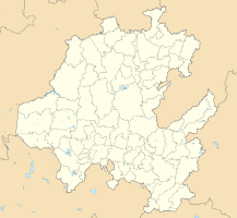
Coordinates: 21 ° 8 ′ N , 98 ° 25 ′ W Huejutla de Reyes on the map of Hidalgo
|
||
| Basic data | ||
| Country | Mexico | |
| State | Hidalgo | |
| Municipio | Huejutla de Reyes | |
| Residents | 40,015 (2010) | |
| City insignia | ||
| Detailed data | ||
| height | 140 m | |
| Post Code | 43000 | |
| prefix | 789 | |
| City Presidency | Alfredo San Roman Duval | |
| Website | ||
| View over the city | ||
Huejutla de Reyes is a city in the north of the state of Hidalgo in Mexico , 217 km north of Pachuca de Soto in the Sierra Madre Oriental . It has 40,000 inhabitants and is the seat of the Municipio Huejutla de Reyes and the Diocese of Huejutla . There is a tropical climate .
history
The city was settled by the Toltecs in 671 . In 1407 the local population came under the rule of the Metztitlán . In 1471 the city was conquered by the Aztecs under Axayacatl .
In 1519 the Spanish conquistador Francisco de Garay sent an expedition led by Alonso Álvarez de Pineda to the area on the Río Pánuco and discovered Huejutla. However, he could not conquer the city and failed. The residents resisted the Spaniards for a long time. In 1522, however, they were defeated by Hernán Cortés and the area was incorporated into his sphere of influence.
On October 4, 1824, when the State of Mexico was established, Huejutla became a part of it until Hidalgo was established in 1866. In the same year the city was besieged by the French invaders of Mexico. Antonio Reyes Cabrera ("El Tordo") organized the defense and was killed during the fighting. The city got its nickname "de Reyes" from him .


