Hugo (Oklahoma)
| Hugo | ||
|---|---|---|
 |
||
| Location in Oklahoma | ||
|
|
||
| Basic data | ||
| State : | United States | |
| State : | Oklahoma | |
| County : | Choctaw County | |
| Coordinates : | 34 ° 1 ′ N , 95 ° 31 ′ W | |
| Time zone : | Central ( UTC − 6 / −5 ) | |
| Residents : | 5,310 (as of 2010) | |
| Population density : | 368.8 inhabitants per km 2 | |
| Area : | 14.4 km 2 (about 6 mi 2 ) of which 14.4 km 2 (about 6 mi 2 ) is land |
|
| Height : | 166 m | |
| Postal code : | 74743 | |
| Area code : | +1 580 | |
| FIPS : | 40-36300 | |
| GNIS ID : | 1094002 | |
| Website : | www.cityofhugo.net | |
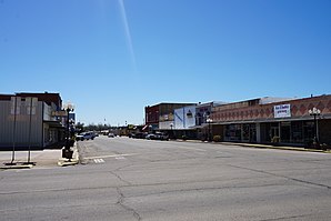
Hugo is a city and county seat of Choctaw County in the US state of Oklahoma . Almost 5300 people live in an area of over 14 square kilometers.
Hugo is part of the Ark-La-Tex socio-economic region , which includes parts of the four states of Arkansas , Louisiana , Oklahoma, and Texas .
geography
Hugo is located in the southeast of Oklahoma in the southern United States, about ten kilometers from the southern Texas border and 95 kilometers from the eastern Arkansas border. In the northeast the Hugo Lake State Park joins with the over 52 square kilometers Hugo Lake . Southwest of the city is the Pat Mayse Lake Nature Reserve .
Nearby cities include Grant (5 km south), Sawyer (7 km east), Soper (15 km west), Rattan (20 km northeast) and Antlers (22 km north). The next larger city with over 1.2 million inhabitants is Dallas in Texas, more than 165 kilometers southwest .
history
Today's urban area of Hugo was once part of a large Indian territory in the United States that was created when the Indians were driven out and fell apart with the establishment of the state of Oklahoma. In what is now County were Choctaw -Indianer located where it got its name.
In the early 20th century, many Jews who fled the increasingly anti-Semitic attitude in Europe settled in Hugo. Most of them were merchants, business owners or peddlers. One of them, Abe Romick, became the state's first Secretary of Commerce and later moved to Alaska . By the early 1950s, almost all Jews had left the city and settled in larger cities like Dallas or Fort Worth . Nowadays there are no more people of Jewish origin in Hugo, so that many residents are not even aware of this part of their city's history.
In 1993 the city's population was hit several times by calamities. There was an exchange of fire in a Walmart parking lot and during just one week in December, two large fires broke out and destroyed a local school and parts of the business center. The historic Belmont Hotel could not be saved either.
traffic
US Highway 70 runs from the northwest to the east of the city and runs for over 3800 kilometers from Arizona in the west to North Carolina in the east. In the southwest around the city also runs the US Highway 271 , which leads from Fort Smith in the north to Tyler . In addition, in the south of the city of the Indian Nation Turnpike , which begins north in Henryetta , joins US Highway 70. Interstate 30 runs about 95 kilometers south of the city .
Demographics
The 2000 census showed a population of 5536 people, divided between 2309 households and 1415 families. The population density was 386 people per square kilometer. 49.3% of the population were white, 30.6% black, 14.1% Native American, 0.3% Asian and under 0.1% Pacific islanders. 0.4% were of a different ethnicity, 5.3% had two or more ethnicities, and 1.6% were Hispanic or Latin American of any ethnicity. For every 100 women there were 80 men. The median age was 38 and the per capita income was over US $ 11,500, bringing almost 30% of the population below the poverty line.
By the 2010 census , the population had fallen slightly to 5310.
Web links
- Website of the City Hugo (Engl.)
- Statistical data on Hugo (Engl.)
