Hurtaut
|
Hurtaut Malacquise |
||
|
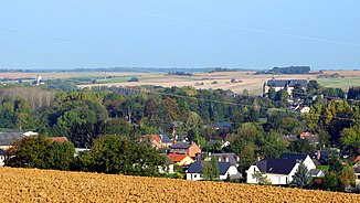
View of the valley of the river near Lislet |
||
| Data | ||
| Water code | FR : H0104000 | |
| location | France , Grand Est and Hauts-de-France regions | |
| River system | His | |
| Drain over | Serre → Oise → Seine → English Channel | |
| source | in the municipality of Signy-l'Abbaye 49 ° 44 ′ 24 ″ N , 4 ° 22 ′ 41 ″ E |
|
| Source height | approx. 245 m | |
| muzzle | at Montcornet in the Serre coordinates: 49 ° 41 ′ 51 " N , 4 ° 0 ′ 34" E 49 ° 41 ′ 51 " N , 4 ° 0 ′ 34" E |
|
| Mouth height | approx. 80 m | |
| Height difference | approx. 165 m | |
| Bottom slope | approx. 4.3 ‰ | |
| length | 38 km | |
The Hurtaut is a river in France that runs through the Grand Est and Hauts-de-France regions. Its source stream rises under the name Ruisseau de Serre in the municipality of Signy-l'Abbaye and generally drains in a south-westerly direction through the Thiérache landscape . Approximately at the level of the hamlet of La Malacquise , in the municipality of Saint-Jean-aux-Bois , the watercourse also changes its name to Malacquise . Below Renneville it reaches the border with the neighboring region of Hauts-de-France, here again changes its name to Hurtaut and also its direction of flow to northwest. Finally, after a total of 38 kilometers, it flows into the Serre as a left tributary at Montcornet . On its way, the Hurtaut crosses the Ardennes and Aisne departments .
