
Rocquigny (Ardennes)
| Rocquigny | ||
|---|---|---|

|
|
|
| region | Grand Est | |
| Department | Ardennes | |
| Arrondissement | Rethel | |
| Canton | Signy-l'Abbaye | |
| Community association | Crêtes Préardennaises | |
| Coordinates | 49 ° 41 ′ N , 4 ° 15 ′ E | |
| height | 128-261 m | |
| surface | 36.85 km 2 | |
| Residents | 686 (January 1, 2017) | |
| Population density | 19 inhabitants / km 2 | |
| Post Code | 08220 | |
| INSEE code | 08366 | |
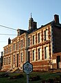
_mairie.JPG) Rocquigny town hall (Mairie) |
||

Rocquigny is a French commune with 686 inhabitants (as of January 1, 2017) in the Ardennes department in the Grand Est region (before 2016 Champagne-Ardenne ); it belongs to the Arrondissement of Rethel and the canton of Signy-l'Abbaye (until 2015 canton of Chaumont-Porcien ).
The formerly independent localities of La Hardoye , Mainbressy and Mainbresson belong to the municipality .
geography
Rocquigny is located about 38 kilometers north-northeast of Reims . Rocquigny is surrounded by the neighboring communities of Résigny in the north and north-west, Le Fréty in the north, Saint-Jean-aux-Bois in the north-east, La Romagne in the east, Chaumont-Porcien in the south and south-west, Rubigny , Vaux-lès-Rubigny and Raillimont in the West, Rouvroy-sur-Serre to the west and north-west and Grandrieux to the north-west.
Population development
| 1962 | 1968 | 1975 | 1982 | 1990 | 1999 | 2006 | 2013 | |
|---|---|---|---|---|---|---|---|---|
| 539 | 541 | 896 | 854 | 775 | 755 | 748 | 669 | |
| Source: Cassini and INSEE | ||||||||
Buildings
- Saint-Christophe Church
- Saint-Urbain church in La Hardoye
- Former town hall of Mainbressy
- grange

Saint Christophe fortified church

Saint-Urbain church

grange
Former town hall of Mainbressy
_%C3%89glise_fortifi%C3%A9e.JPG)
_%C3%A9glise_Saint-Urbain_de_La_Hardoye.JPG)
_ferme-manoir.JPG)

Personalities
- Jean-François Pierret (1738–1796), lawyer and politician