Saint-Fergeux
| Saint-Fergeux | ||
|---|---|---|
|
|
||
| region | Grand Est | |
| Department | Ardennes | |
| Arrondissement | Rethel | |
| Canton | Château-Porcien | |
| Community association | Pays Rethélois | |
| Coordinates | 49 ° 34 ' N , 4 ° 13' E | |
| height | 76-161 m | |
| surface | 25.5 km 2 | |
| Residents | 210 (January 1, 2017) | |
| Population density | 8 inhabitants / km 2 | |
| Post Code | 08360 | |
| INSEE code | 08380 | |
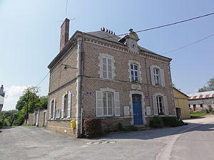
 Town hall ( Mairie ) and school of Saint-Fergeux |
||
Saint-Fergeux is a French commune with 210 inhabitants (as of January 1, 2017) in the Ardennes department in the Grand Est region (until 2015 Champagne-Ardenne ). It belongs to the Arrondissement of Rethel , the canton of Château-Porcien and the Pays Rethélois municipality .
geography
Saint-Fergeux is surrounded by the neighboring communities of Son in the east, the canton capital Château-Porcien in the south-east, Condé-lès-Herpy in the south, Banogne-Recouvrance in the west, Hannogne-Saint-Rémy in the north-west, Seraincourt in the north and the in the canton Signy-l'Abbaye municipality of Remaucourt in the northeast.
Population development
| year | 1962 | 1968 | 1975 | 1982 | 1990 | 1999 | 2004 | 2009 | 2016 |
| Residents | 338 | 309 | 253 | 207 | 203 | 197 | 198 | 206 | 207 |
| Source: Cassini and INSEE | |||||||||
Attractions
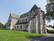
- Saint-Ferréol church, built in the 16th century, monument historique since 1926
Web links
Commons : Saint-Fergeux - Collection of images, videos and audio files
Individual evidence
- ↑ Entry no. PA00078498 in the Base Mérimée of the French Ministry of Culture (French)

