Sault-lès-Rethel
| Sault-lès-Rethel | ||
|---|---|---|
|
|
||
| region | Grand Est | |
| Department | Ardennes | |
| Arrondissement | Rethel | |
| Canton | Rethel | |
| Community association | Pays Rethélois | |
| Coordinates | 49 ° 30 ' N , 4 ° 22' E | |
| height | 68-146 m | |
| surface | 6.45 km 2 | |
| Residents | 1,915 (January 1, 2017) | |
| Population density | 297 inhabitants / km 2 | |
| Post Code | 08300 | |
| INSEE code | 08403 | |
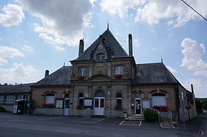
 Sault-lès-Rethel town hall |
||
Sault-lès-Rethel is a French commune with 1,915 inhabitants (as of January 1, 2017) in the Ardennes department in the Grand Est region . The municipality belongs to the arrondissement of Rethel and the canton of Rethel .
geography
Sault-lès-Rethel is about 35 kilometers north-east of Reims and is a banlieue in the south of Rethel . The Canal des Ardennes (Ardennes Canal ) runs through the municipality . The Aisne River limits the municipality to the north and northeast. Sault-lès-Rethel is surrounded by the neighboring communities of Rethel in the north, Biermes in the east and south-east, Perthes in the south, Tagnon in the south-west and Acy-Romance in the west.
The Route nationale 51 borders the municipality in the west.
Population development
| 1962 | 1968 | 1975 | 1982 | 1990 | 1999 | 2006 | 2012 | |
|---|---|---|---|---|---|---|---|---|
| 1,254 | 1,599 | 2,018 | 2.116 | 2,067 | 1.919 | 1,863 | 1.923 | |
| Source: Cassini and INSEE | ||||||||
Attractions
- church
Web links
Commons : Sault-lès-Rethel - Collection of images, videos and audio files
