
Condé-lès-Herpy
| Condé-lès-Herpy | ||
|---|---|---|
|
||
| region | Grand Est | |
| Department | Ardennes | |
| Arrondissement | Rethel | |
| Canton | Château-Porcien | |
| Community association | Pays Rethélois | |
| Coordinates | 49 ° 32 ' N , 4 ° 14' E | |
| height | 65–157 m | |
| surface | 11.55 km 2 | |
| Residents | 217 (January 1, 2017) | |
| Population density | 19 inhabitants / km 2 | |
| Post Code | 08360 | |
| INSEE code | 08126 | |
_Mairie.JPG) Town hall ( Mairie ) of Condé-lès-Herpy |
||

Condé-lès-Herpy is a French commune with 217 inhabitants (as of January 1, 2017) in the Ardennes department in the Grand Est region (until 2015 Champagne-Ardenne ). It belongs to the Arrondissement of Rethel , the canton of Château-Porcien and the Pays Rethélois municipality . The inhabitants are called Condéens .
geography
Condé-lès-Herpy is on the Aisne . Condé-lès-Herpy is surrounded by the neighboring communities of Saint-Fergeux in the north, Château-Porcien in the east, Herpy-l'Arlésienne in the south, Saint-Germainmont in the south-west and Banogne-Recouvrance in the north-west.
Population development
| year | 1962 | 1968 | 1975 | 1982 | 1990 | 1999 | 2006 | 2011 | 2016 |
| Residents | 148 | 137 | 118 | 139 | 172 | 159 | 184 | 209 | 218 |
| Source: Cassini and INSEE | |||||||||
Attractions
- church
- War memorial
- Oratorio
- Wayside cross
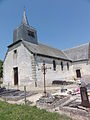
church
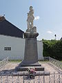
War memorial

Oratorio

Wayside cross
_%C3%89glise.JPG)
_Monument_aux_morts.JPG)
_Chapelle-oratoire.JPG)
_croix_de_chemin.JPG)
Web links
Commons : Condé-lès-Herpy - collection of images, videos and audio files