
Saint-Quentin-le-Petit
| Saint-Quentin-le-Petit | ||
|---|---|---|
|
||
| region | Grand Est | |
| Department | Ardennes | |
| Arrondissement | Rethel | |
| Canton | Château-Porcien | |
| Community association | Pays Rethélois | |
| Coordinates | 49 ° 35 ' N , 4 ° 5' E | |
| surface | 8.95 km 2 | |
| Residents | 120 (January 1, 2017) | |
| Population density | 13 inhabitants / km 2 | |
| Post Code | 08220 | |
| INSEE code | 08396 | |
 View of Saint-Quentin-le-Petit |
||

Saint-Quentin-le-Petit is a French commune with 120 inhabitants (as of January 1, 2017) in the Ardennes department in the Grand Est region (until 2015: Champagne-Ardenne ). It belongs to the Arrondissement of Rethel , the canton of Château-Porcien and the Pays Rethélois municipality .
geography
The municipality is crossed by the Barres River. Saint-Quentin-le-Petit is surrounded by the neighboring municipalities of Sévigny-Waleppe in the north, Hannogne-Saint-Rémy in the northeast, Banogne-Recouvrance in the east, Le Thour in the south and the municipality of Nizy in the Hauts-de-France region -le-Comte to the west.
history
During the French Revolution , the community was temporarily called Unity .
Population development
| year | 1962 | 1968 | 1975 | 1982 | 1990 | 1999 | 2006 | 2013 | 2016 |
| Residents | 207 | 167 | 131 | 126 | 163 | 158 | 152 | 124 | 117 |
| Source: Cassini and INSEE | |||||||||
Attractions
- Valroy Monastery , former Cistercian abbey
- Saint-Quentin Church

Ruins of the Valroy monastery
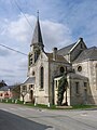
Saint-Quentin Church


Web links
Commons : Saint-Quentin-le-Petit - collection of images, videos and audio files