Ménil-Lépinois
| Ménil-Lépinois | ||
|---|---|---|

|
|
|
| region | Grand Est | |
| Department | Ardennes | |
| Arrondissement | Rethel | |
| Canton | Château-Porcien | |
| Community association | Pays Rethélois | |
| Coordinates | 49 ° 23 ′ N , 4 ° 17 ′ E | |
| height | 94-159 m | |
| surface | 18.01 km 2 | |
| Residents | 136 (January 1, 2017) | |
| Population density | 8 inhabitants / km 2 | |
| Post Code | 08310 | |
| INSEE code | 08287 | |
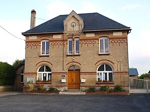
 Town hall (Mairie) of Ménil-Lépinois |
||
Ménil-Lépinois is a French commune with 136 inhabitants (as of January 1, 2017) in the Ardennes department in the Grand Est region (before 2016 Champagne-Ardenne ). It belongs to the Arrondissement of Rethel , the canton of Château-Porcien (until 2015 Juniville ) and the Pays Rethélois municipality .
geography
Ménil-Lépinois is surrounded by the neighboring communities of Saint-Remy-le-Petit in the west, Bergnicourt and Le Châtelet-sur-Retourne in the north-west, Neuflize in the north, Alincourt in the north-east, Juniville in the east, Aussonce in the south-east and that in the Marne department located municipality of Warmeriville in the south.
Population development
| year | 1962 | 1968 | 1975 | 1982 | 1990 | 1999 | 2006 | 2011 | 2016 |
| Residents | 132 | 108 | 86 | 104 | 103 | 92 | 97 | 137 | 131 |
| Source: Cassini and INSEE | |||||||||
Attractions
- Saint Martin Church
Web links
Commons : Ménil-Lépinois - collection of images, videos and audio files

