Saulces-Monclin
| Saulces-Monclin | ||
|---|---|---|
|
|
||
| region | Grand Est | |
| Department | Ardennes | |
| Arrondissement | Rethel | |
| Canton | Signy-l'Abbaye | |
| Community association | Crêtes Préardennaises | |
| Coordinates | 49 ° 35 ′ N , 4 ° 30 ′ E | |
| height | 83-177 m | |
| surface | 20.23 km 2 | |
| Residents | 811 (January 1, 2017) | |
| Population density | 40 inhabitants / km 2 | |
| Post Code | 08270 | |
| INSEE code | 08402 | |
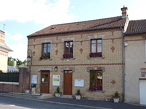
 Town hall (Mairie) of Saulces-Monclin |
||
Saulces-Monclin is a French commune with 811 inhabitants (as of January 1, 2017) in the Ardennes department in the Grand Est region (before 2016 Champagne-Ardenne ); it belongs to the arrondissement of Rethel and the canton of Signy-l'Abbaye (until 2015 canton of Novion-Porcien ).
geography
Saulces-Monclin is located about 48 kilometers northeast of Reims on the Saulces River . Saulces-Monclin is surrounded by the neighboring communities of Faissault in the north, Puiseux in the northeast, Vaux-Montreuil in the east, Chesnois-Auboncourt in the east and southeast, Sorcy-Bauthémont in the south and southeast, Faux in the south, Auboncourt-Vauzelles in the south and southwest as well Corny-Machéroménil to the west.
The A34 autoroute runs through the municipality .
Population development
| year | 1962 | 1968 | 1975 | 1982 | 1990 | 1999 | 2006 | 2011 | 2016 |
| Residents | 596 | 526 | 518 | 474 | 513 | 528 | 617 | 689 | 802 |
| Source: Cassini and INSEE | |||||||||
Buildings
- Saint-Nicolas church
- Chapel of Sainte-Marie
- Soldiers graves
Personalities
- Gustave Pasquier (1877–1965), racing cyclist

