
Chaumont-Porcien
| Chaumont-Porcien | ||
|---|---|---|

|
|
|
| region | Grand Est | |
| Department | Ardennes | |
| Arrondissement | Rethel | |
| Canton | Signy-l'Abbaye | |
| Community association | Crêtes Préardennaises | |
| Coordinates | 49 ° 39 ′ N , 4 ° 15 ′ E | |
| height | 100-240 m | |
| surface | 35.97 km 2 | |
| Residents | 485 (January 1, 2017) | |
| Population density | 13 inhabitants / km 2 | |
| Post Code | 08220 | |
| INSEE code | 08113 | |
| Website | http://www.chaumontporcien.info/ | |
_Mairie.JPG) Town hall (Mairie) of Chaumont-Porcien |
||

Chaumont-Porcien is a French commune with 485 inhabitants (as of January 1, 2017) in the Ardennes department in the Grand Est region (before 2016 Champagne-Ardenne ); it belongs to the Arrondissement of Rethel and the canton of Signy-l'Abbaye (until 2015 canton of Chaumont-Porcien ).
The formerly independent localities Logny-lès-Chaumont and Wadimont belong to the municipality .
geography
Chaumont-Porcien is located about 38 kilometers north-northeast of Reims . Chaumont-Porcien is surrounded by the neighboring communities of Rocquigny in the north, La Romagne in the north-east, Givron in the east, Doumely-Bégny in the east and south-east, Chappes in the south and south-east, Remaucourt in the south, Seraincourt in the south-west, Fraillicourt in the west and Vaux-lès -Rubigny and Rubigny in the northwest.
Population development
| 1962 | 1968 | 1975 | 1982 | 1990 | 1999 | 2006 | 2013 | |
|---|---|---|---|---|---|---|---|---|
| 425 | 382 | 569 | 478 | 479 | 473 | 457 | 472 | |
| Source: Cassini and INSEE | ||||||||
Buildings
- Church in Chaumont-Porcien
- Church in Logny-Lés-Chaumont
- Chapel of the Hermitage of Saint Bertauld

Church of Chaumont-Porcien

Logny-lès-Chaumont church
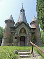
Chapel of the Hermitage of Saint-Bertauld

_%C3%89glise.JPG)
_entree_de_la_chapelle_comm%C3%A9morative.JPG)