Mont-Laurent
| Mont-Laurent | ||
|---|---|---|
|
|
||
| region | Grand Est | |
| Department | Ardennes | |
| Arrondissement | Rethel | |
| Canton | Rethel | |
| Community association | Pays Rethélois | |
| Coordinates | 49 ° 28 ′ N , 4 ° 29 ′ E | |
| surface | 6.83 km 2 | |
| Residents | 62 (January 1, 2017) | |
| Population density | 9 inhabitants / km 2 | |
| Post Code | 08130 | |
| INSEE code | 08306 | |
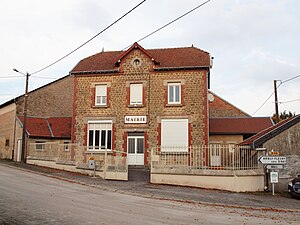
 Town Hall ( Mairie ) of Mont-Laurent |
||
Mont-Laurent is a French commune with 62 inhabitants (as of January 1, 2017) in the Ardennes department in the Grand Est region (until 2015 Champagne-Ardenne ). It belongs to the canton of Rethel in the arrondissement of Rethel as well as to the community association Pays Rethélois .
geography
Mont-Laurent is surrounded by the neighboring municipalities of Seuil in the west, Ambly-Fleury in the north, the municipalities of Givry in the canton of Attigny in the northeast and Saulces-Champenoises in the east and southeast and the municipality of Ménil-Annelles in the canton of Château-Porcien Southwest.
Population development
| year | 1962 | 1968 | 1975 | 1982 | 1990 | 1999 | 2005 | 2015 | 2016 |
|---|---|---|---|---|---|---|---|---|---|
| Residents | 103 | 106 | 93 | 83 | 79 | 75 | 71 | 67 | 63 |
| Source: Cassini and INSEE | |||||||||
Attractions
- Saint Laurent Church
Web links
Commons : Mont-Laurent - Collection of images, videos and audio files

