
Justine-Herbigny
| Justine-Herbigny | ||
|---|---|---|
|
||
| region | Grand Est | |
| Department | Ardennes | |
| Arrondissement | Rethel | |
| Canton | Signy-l'Abbaye | |
| Community association | Crêtes Préardennaises | |
| Coordinates | 49 ° 36 ′ N , 4 ° 20 ′ E | |
| height | 79-179 m | |
| surface | 11.77 km 2 | |
| Residents | 175 (January 1, 2017) | |
| Population density | 15 inhabitants / km 2 | |
| Post Code | 08270 | |
| INSEE code | 08240 | |
_mairie_Herbigny.JPG) Mairie Justine-Herbigny |
||

Justine-Herbigny is a French commune with 175 inhabitants (as of January 1, 2017) in the Ardennes department in the Grand Est region (until 2015 Champagne-Ardenne ). It belongs to the Arrondissement of Rethel and to the community association Crêtes Préardennaises founded in 1995 .
geography
Justine-Herbigny is located at the confluence of the Draize and the Vaux , about 42 kilometers northeast of Reims in the northwest of the Dry Champagne south of the Ardennes . The 11.77 km² area of the municipality, which is poorly forested except for smaller trees, is characterized by grain fields. From the south a range of hills called Montagne de Sery protrudes into the municipality. The highest point in the municipality is reached here at 179 meters above sea level, while the villages of Justine and Herbigny are 87 and 88 m above sea level, respectively. Justine-Herbigny is surrounded by the neighboring communities of Draize and Wasigny in the northeast, Sery in the southeast, Hauteville in the southwest, Chappes in the west and Doumely-Bégny in the northwest.
history
The community was created in 1965 from the merger of the formerly independent communities Justine and Herbigny.
Population development
| 1962 | 1968 | 1975 | 1982 | 1990 | 1999 | 2006 | 2016 |
|---|---|---|---|---|---|---|---|
| 113 | 199 | 169 | 159 | 135 | 114 | 160 | 177 |
| Sources: Cassini and INSEE | |||||||
Attractions
- Saint Martin Church in Herbigny
- Notre-Dame church in Justine
- Watermill on the Vaux in Justine, Monument historique
- Oratory in Herbigny
- two memorials to the fallen
- two lavoirs and several fountains

Saint Martin Church in Herbigny

Notre-Dame church in Justine

old watermill in Justine
_%C3%A9glise_Saint-Martin_d%27Herbigny_(2).JPG)
_%C3%A9glise_Notre-Dame_de_Justine_(2).JPG)
_moulin_sur_la_Vaux_%C3%A0_Justine_MH.JPG)

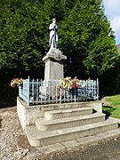
Fallen memorial in Justine
Monument to the fallen in Herbigny

Oratory in Herbigny
_monument_aux_morts_Justine.JPG)
_monument_aux_morts_Herbigny.JPG)
_chapelle-oratoire_%C3%A0_Herbigny.JPG)
Economy and Infrastructure
The community is rural. Nine farms are located in Justine-Herbigny (grain cultivation, cattle, goat and sheep breeding)
Justine-Herbigny is located away from the nationally important traffic arteries. The town of Rethel , twelve kilometers away, is a local transport hub with connections to the A34 autoroute . Rethel station is on the railway line from Soissons to Givet .
supporting documents
- ↑ Information on cassini.ehess.fr (French)
- ↑ Justine-Herbigny on cassini.ehess.fr
- ↑ Justine-Herbigny on INSEE
- ^ Entry in the Base Mérimée of the Ministry of Culture. Retrieved March 1, 2019 (French).
- ↑ farms on annuaire-mairie.fr (French)