
Wignicourt
| Wignicourt | ||
|---|---|---|
|
||
| region | Grand Est | |
| Department | Ardennes | |
| Arrondissement | Rethel | |
| Canton | Signy-l'Abbaye | |
| Community association | Crêtes Préardennaises | |
| Coordinates | 49 ° 35 ′ N , 4 ° 35 ′ E | |
| height | 134-230 m | |
| surface | 4.49 km 2 | |
| Residents | 58 (January 1, 2017) | |
| Population density | 13 inhabitants / km 2 | |
| Post Code | 08270 | |
| INSEE code | 08500 | |
 Mairie Wignicourt |
||

Wignicourt (1793 and 1801 still not spelled Vuignicourt ) is a French commune in the Ardennes department in the Grand Est region (until 2015 Champagne-Ardenne ) with 58 inhabitants (as of January 1, 2017). It belongs to the Arrondissement of Rethel and to the community association Crêtes Préardennaises founded in 1995 .
geography
Wignicourt is located on the Foivre River , a tributary of the Aisne , about 24 kilometers southwest of Charleville-Mézières in the hill country south of the Ardennes . Wignicourt is surrounded by the neighboring communities of Hagnicourt in the north, Mazerny in the northeast, Saint-Loup-Terrier in the east, Chesnois-Auboncourt in the south and Vaux-Montreuil in the west.
Population development
| 1962 | 1968 | 1975 | 1982 | 1990 | 1999 | 2007 | 2016 | ||
|---|---|---|---|---|---|---|---|---|---|
| 83 | 61 | 61 | 44 | 52 | 61 | 66 | 59 | ||
| Sources: Cassini and INSEE | |||||||||
Attractions
- Saint Joseph Church
- War memorial

Saint Joseph Church

War memorial
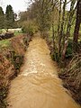
The Foivre River in Wignicourt
_%C3%A9glise.JPG)
_monument_aux_morts.JPG)

Economy and Infrastructure
There are two farms in Wignicourt.
On the eastern edge of the municipality of Wignicourt, the D987 trunk road runs from Poix-Terron to Attigny . Six kilometers west of Wignicourt there is a connection to the A34 autoroute from Reims to Sedan .
supporting documents
- ↑ toponym on cassini.ehess.fr
- ↑ Wignicourt on cassini.ehess.fr
- ↑ Wignicourt on insee.fr
- ↑ Farms on annuaire-mairie.fr (French)