Saint Loup Terrier
| Saint Loup Terrier | ||
|---|---|---|

|
|
|
| region | Grand Est | |
| Department | Ardennes | |
| Arrondissement | Vouziers | |
| Canton | Attigny | |
| Community association | Crêtes Préardennaises | |
| Coordinates | 49 ° 35 ' N , 4 ° 37' E | |
| height | 124-236 m | |
| surface | 15.3 km 2 | |
| Residents | 179 (January 1, 2017) | |
| Population density | 12 inhabitants / km 2 | |
| Post Code | 08130 | |
| INSEE code | 08387 | |
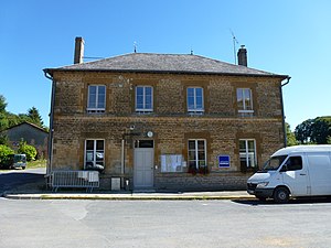
 Town hall ( Mairie ) of Saint Loup Terrier |
||
Saint-Loup-Terrier is a French commune with 179 inhabitants (as of January 1, 2017) in the Ardennes department in the Grand Est region (until 2015 Champagne-Ardenne ). It belongs to the arrondissement of Vouziers , the canton of Attigny (until 2015: canton of Tourteron ) and the community association Crêtes Préardennaises .
geography
Saint-Loup-Terrier is located on the Saint-Lambert River . Neighboring municipalities are Jonval and Tourteron in the southeast, Guincourt in the south, Écordal in the southwest, the municipalities of Chesnois-Auboncourt in the canton of Signy-l'Abbaye in the west and Wignicourt in the northwest and the municipalities of Mazerny in the canton of Nouvion-sur-Meuse North, Baâlons to the northeast and Bouvellemont to the east.
history
The current municipality was created in 1828 when the municipalities of Saint-Loup-aux-Bois and Terrier merged .
Population development
| year | 1962 | 1968 | 1975 | 1982 | 1990 | 1999 | 2006 | 2013 | 2016 |
|---|---|---|---|---|---|---|---|---|---|
| Residents | 218 | 203 | 166 | 156 | 167 | 154 | 160 | 170 | 178 |
| Source: Cassini and INSEE | |||||||||
Attractions
- Saint-Loup church with frescoes and a 16th century vault (inaccessible to the public), monument historique since 1984
Personalities
- Heinrich de Briquemault (1620–1692), Lieutenant General and Governor of Lippstadt
Web links
Individual evidence
- ↑ Entry no. PA00078501 in the Base Mérimée of the French Ministry of Culture (French)

