
Harricourt
| Harricourt | ||
|---|---|---|
.svg)
|
|
|
| region | Grand Est | |
| Department | Ardennes | |
| Arrondissement | Vouziers | |
| Canton | Vouziers | |
| Community association | L'Argonne Ardennaise | |
| Coordinates | 49 ° 26 ' N , 4 ° 56' E | |
| height | 165-261 m | |
| surface | 7.87 km 2 | |
| Residents | 40 (January 1, 2017) | |
| Population density | 5 inhabitants / km 2 | |
| Post Code | 08240 | |
| INSEE code | 08215 | |
 Harricourt Town Hall ( Mairie ) |
||

Harricourt is a French commune with 40 inhabitants (as of January 1, 2017) in the Ardennes department in the Grand Est region (until 2015: Champagne-Ardenne ). It belongs to the arrondissement of Vouziers , to the canton of Vouziers (until 2015: canton of Buzancy ) and to the community association L'Argonne Ardennaise, founded in 1997 .
geography
Harricourt is surrounded by the neighboring communities of Saint-Pierremont in the north, Bar-lès-Buzancy in the east, Buzancy in the south-east, Thénorgues in the south, Briquenay in the south-west, Germont in the west and Autruche in the north-west.
history
In 1828 the parishes of Bar (today: Bar-lès-Buzancy) and Harricourt merged to form the parish of Bar-et-Harricourt . The merger was canceled again in 1871.
Population development
| year | 1962 | 1968 | 1975 | 1982 | 1990 | 1999 | 2006 | 2012 | 2016 |
| Residents | 100 | 80 | 70 | 74 | 71 | 60 | 53 | 39 | 38 |
| Source: Cassini and INSEE | |||||||||
Attractions
- Saint-Rémy church
- La Chambrerie, a 13th century fortress
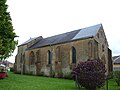
Saint-Rémy church

Mill and fortress

