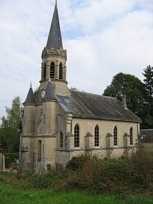
Lançon (Ardennes)
| Lançon | ||
|---|---|---|

|
|
|
| region | Grand Est | |
| Department | Ardennes | |
| Arrondissement | Vouziers | |
| Canton | Attigny | |
| Community association | Argonne Ardennaise | |
| Coordinates | 49 ° 17 ′ N , 4 ° 52 ′ E | |
| height | 107-218 m | |
| surface | 8.24 km 2 | |
| Residents | 33 (January 1, 2017) | |
| Population density | 4 inhabitants / km 2 | |
| Post Code | 08250 | |
| INSEE code | 08245 | |
Lançon is a French commune with 33 inhabitants (as of January 1, 2017) in the Ardennes department in the Grand Est region (before 2016 Champagne-Ardenne ). It belongs to the arrondissement of Vouziers , the canton of Attigny (until 2015 canton of Grandpré ) and the community association Argonne Ardennaise .
geography
Lançon is surrounded by the neighboring municipalities of Condé-lès-Autry in the southwest, Autry in the west, Grandham in the northwest, Senuc in the north, Cornay in the northeast, Chatel-Chéhéry in the southeast and the municipality of Binarville in the Marne department in the south.
Population development
| year | 1962 | 1968 | 1975 | 1982 | 1990 | 1999 | 2004 | 2009 | 2016 |
|---|---|---|---|---|---|---|---|---|---|
| Residents | 70 | 43 | 43 | 34 | 41 | 40 | 39 | 39 | 34 |
| Source: Cassini and INSEE | |||||||||
Attractions
- Saint-Christophe Church
Web links
Commons : Lançon - collection of images, videos and audio files

