
Semide (Ardennes)
| Semide | ||
|---|---|---|

|
|
|
| region | Grand Est | |
| Department | Ardennes | |
| Arrondissement | Vouziers | |
| Canton | Attigny | |
| Community association | Argonne Ardennaise | |
| Coordinates | 49 ° 21 ′ N , 4 ° 35 ′ E | |
| height | 110-204 m | |
| surface | 37.04 km 2 | |
| Residents | 190 (January 1, 2017) | |
| Population density | 5 inhabitants / km 2 | |
| Post Code | 08400 | |
| INSEE code | 08410 | |
 Town Hall Mairie of Semide |
||

Semide is a French commune with 190 inhabitants (as of January 1, 2017) in the Ardennes department in the Grand Est region (until 2015 Champagne-Ardenne ). It belongs to the arrondissement of Vouziers , the canton of Attigny (until 2015: canton of Machault ) and the Argonne Ardennaise municipality .
geography
Semide is surrounded by the neighboring municipalities of Saint-Étienne-à-Arnes in the west, Machault in the northwest, Leffincourt in the north, Contreuve in the northeast, Mont-Saint-Martin in the east, Liry and Aure in the southwest and the municipality of Sommepy in the Marne department -Tahure in the south. The hamlets of Orfeuil , Baimont and La ferme de Scay belong to the municipality.
Population development
| year | 1962 | 1968 | 1975 | 1982 | 1990 | 1999 | 2009 | 2015 | 2016 |
| Residents | 314 | 293 | 251 | 264 | 258 | 245 | 213 | 195 | 196 |
| Source: Cassini and INSEE | |||||||||
Attractions
- Saint-Pierre-et-Saint-Paul church, built in the 12th century
- German artillery platform from 1916, Monument historique since 1922
- Orfeuil war cemetery

Saint-Pierre-et-Saint-Paul church
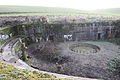
Artillery platform

Orfeuil war cemetery


Web links
Individual evidence
- ↑ Entry no. PA00078525 in the Base Mérimée of the French Ministry of Culture (French)