Canal des Ardennes
| Canal des Ardennes | |
|---|---|
|
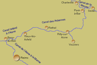
Course sketch of the canal |
|
| Water code | FR : B5-0102 , FR : H1-0102 , FR : H12-4012 |
| location | France , Grand Est region |
| length | 99 km |
| Built | 1827-1831 |
| Expanded | 1842-1846 |
| class | I ( Freycinet class ) |
| Beginning | Branch from the Canal de la Meuse at Pont-à-Bar |
| The End | Crossing into the Canal latéral à l'Aisne near Vieux-lès-Asfeld |
| Descent structures | 48 |
| Ports | Vouziers , Rethel , Asfeld |
| Junctions, crossings | Branch canal to Vouziers |
| Used river | Bar , Aisne |
| Outstanding structures | Saint-Aignan tunnel , Le Chesne lock chain |
| Kilometrage | Direction to the Aisne or in its direction of flow |
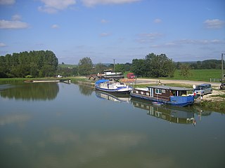
| The canal at Pont-à-Bar | |
The Canal des Ardennes (German Ardennes Canal ) is a French shipping canal that runs in the Ardennes department in the Grand Est region .
geography
The canal is part of an inland waterway that connects Belgium and the Ardennes area with the greater Paris area. This route consists of the following waterways:
- Maas (French: Meuse ) - as a canalized river
- Canal de la Meuse (formerly: Canal de l'Est - branche Nord )
- Canal des Ardennes
- Canal latéral à l'Aisne
- Aisne - as a canalized river
- Oise - as a canalized river
Course and technical infrastructure
The Canal des Ardennes begins in the town of Pont-à-Bar , in the municipality of Dom-le-Mesnil , where it connects to the Canal de la Meuse (German: Maas Canal ) and ends at Vieux-lès-Asfeld , where it merges into the Canal latéral à l'Aisne. It has a total length of 99 kilometers.
It consists of 2 sections with separate mileage counting
- from Pont-à-Bar to Rilly-sur-Aisne
- This part is a canal of the watershed type , has a length of 39 kilometers and follows the river Bar to the watershed at Le Chesne . There is a tunnel at Saint-Aignan . It has 34 locks , 27 of which are over a distance of only nine kilometers on the descent to the Aisne, which it reaches at Rilly-sur-Aisne.
- from Vouziers to Vieux-lès-Asfeld
- This part is a canal of the side canal type , follows the Aisne River for 60 kilometers and has 14 locks.
Both sections meet in Rilly-sur Aisne, where a branch canal leads to Vouziers.
Coordinates
Part 1:
- Starting point of the canal: 49 ° 41 ′ 37 ″ N , 4 ° 49 ′ 46 ″ E
- End point of the canal: 49 ° 29 ′ 25 ″ N , 4 ° 38 ′ 38 ″ E
Section 2:
- Starting point of the canal: 49 ° 24 ′ 14 " N , 4 ° 42 ′ 13" E
- End point of canal: 49 ° 27 '28 " N , 4 ° 5' 53" E
Places on the canal
- Pont-à-bar
- Le Chesne
- Neuville Day
- Rilly-sur-Aisne
- Vouziers (via branch canal)
- Rethel
- Asfeld
- Vieux-lès-Asfeld
history
- 1823 Start of construction work
- 1827–1831 Opening of the canal in stages
- 1836 Opening of the Vouziers branch canal for shipping
- 1842–1846 Modernization of the Le Chesne lock staircase
Economical meaning
Freight shipping has gradually lost its importance. Nevertheless, the waterway is still used more frequently by cargo ships today. Pleasure boats and houseboats are less common than other waterways.
Web links
- Information on the channel in the Babel project (French)
- Saint-Aignan Canal Tunnel. In: Structurae
- Tourism on the canal
literature
- David Edwards-May, Inland Waters of France , 5th edition, Verlag Edition Maritim, Hamburg 1997, ISBN 3-922117-61-9
- Navicarte Guide de navigation fluvial - n ° 8 , July 2005, Edition Grafocarte, ISBN 2-7416-0162-3
Individual evidence
- ↑ a b The information on the length of the canal is based on the information on the Canal des Ardennes (ascent to vertex posture) at SANDRE (French), the Canal des Ardennes (descent from vertex posture) at SANDRE (French), and the Vouziers branch canal at SANDRE (French ), accessed on December 8, 2011, rounded to full kilometers.


