
Ier
|
Ier Ér, Eriu |
||
 Frozen part of the Iers |
||
| Data | ||
| location | Counties Satu Mare , Bihor ( Romania ), Hungary |
|
| River system | Danube | |
| Drain over | Berettyó → Sebes-Körös → Körös → Tisza → Danube → Black Sea | |
| origin | at Supur in the Satu Mare district 47 ° 26 ′ 28 ″ N , 22 ° 42 ′ 41 ″ E |
|
| muzzle | near Pocsaj in the Berettyó coordinates: 47 ° 16 ′ 41 ″ N , 21 ° 47 ′ 58 ″ E 47 ° 16 ′ 41 ″ N , 21 ° 47 ′ 58 ″ E
|
|
| length | approx. 120 km | |
| Small towns | Săcueni , Diosig | |
| Communities | Pocsaj | |
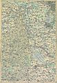
 Course of the Ier in Romania |
||
The Ier ( Hungarian Ér ; Romanian Ier or Eriu ) is a river in Transylvania in Romania and in eastern Hungary .
The source is in Satu Mare County (Romania). It then flows through the Bihor County and flows into the Berettyó near Pocsaj in Hajdú-Bihar County (Hungary) .
The following cities and municipalities are on the Ier (from the source to the mouth):
- Romania: Unimăt , Mihăieni , Eriu-Sâncrai , Sudurău , Ady Endre Căuaș , Hotoan , Sălacea , Tarcea, Adoni , Săcueni , Diosig
- Hungary: Pocsaj
Historical maps

Ér Bach at the mouth near Poscay (center) around 1782 (recording sheet of the Josephinische Landesaufnahme )
Ér river at Săcueni (Székelyhíd) between 1782 and 1785

Ér bei Adoni (Ér-Adony, top left) between 1782 and 1785

Nagy Ér a swampy stream (natural border with Hungarn) near Sudurău (Szodoro) between 1769 and 1773

Nagy Ér a swamp with a stream (natural border with Hungarn) near Ghirolt (Girolt) between 1769 and 1773

Ér Patak near Eriu-Sâncrai (Szent Kiraly) and Mihăieni (Mihályfalva) between 1769 and 1773
Ér Patak at Unimăt (Uj Nemethi) between 1769 and 1773

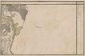
The estuary at Pocsaj (N 47 ° 17 '; E 39 ° 28') around 1892 (record sheet of the Franzisco-Josephinische Landesaufnahme )

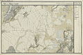
River course beginning at (N 47 ° 17 '; E 39 ° 30') and source at (N 47 ° 29 '; E 40 ° 25') around 1892
Course of the river at Unimăt (Ujnémet) (N 47 ° 30 '; E 40 ° 25') around 1892


Web links
- Ér , in: A Pallas Nagy Lexikona (Hungarian)