
Săcueni
|
Săcueni Zickelhid Székelyhíd |
|||||
|
|||||
| Basic data | |||||
|---|---|---|---|---|---|
| State : |
|
||||
| Historical region : | Screeching area | ||||
| Circle : | Bihor | ||||
| Coordinates : | 47 ° 21 ' N , 22 ° 5' E | ||||
| Time zone : | EET ( UTC +2) | ||||
| Height : | 130 m | ||||
| Area : | 151.40 km² | ||||
| Residents : | 11,526 (October 20, 2011) | ||||
| Population density : | 76 inhabitants per km² | ||||
| Postal code : | 417435 | ||||
| Telephone code : | (+40) 02 59 | ||||
| License plate : | bra | ||||
| Structure and administration (as of 2016) | |||||
| Community type : | city | ||||
| Structure : | 5 districts / cadastral communities: Cadea , Ciocaia , Cubulcut , Olosig , Sânnicolau de Munte | ||||
| Mayor : | Csaba Béres ( UDMR ) | ||||
| Postal address : | Libertății street, no. 5 loc. Săcueni, jud. Bihor, RO-417435 |
||||
| Website : | |||||


Săcueni [ ˈsəkuenʲ ] ( German Zickelhid , Hungarian Székelyhíd for bridge of the Szekler ) is a town in the Bihor district in Romania .
Geographical location

Săcueni is located in the Kreisch area on the edge of the Great Hungarian Plain and at its transition to the northwestern foothills of the Apuseni Mountains . The district capital Oradea is located about 35 kilometers south. The Romanian-Hungarian border runs just 7 km west of the city center. The Ier flows through the city .
history
The region of today's city has been populated since the Neolithic . Other archaeological finds come from the Iron , Bronze and Dacian ages . The Gepids and Avars settled here during the Great Migration . Around the year 1000 the Hungarians took possession of the area. The place was first mentioned in a document in 1217. In the first half of the 15th century (documented evidence in 1455) it received city rights. In the following time the relative importance of the place decreased. In the 16th and 17th centuries it belonged temporarily to the Ottoman Empire , then to Austria-Hungary . The fortifications were razed after the Treaty of Eisenburg in 1664. In the last decades of the Habsburg Monarchy, Székelyhíd / Săcueni was the seat of a chair district in Bihar County . As a result of the First World War , Săcueni came to Romania despite its Hungarian majority. As a result of the Second Vienna Arbitration , the place came back temporarily to Hungary from 1940 to 1944. After a referendum in 2003, Săcueni was declared a city again in 2004. Main branches of business are agriculture and livestock, food, metal and wood processing.

Golden Dacian bangle from the Săcueni area
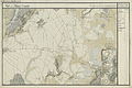
Székelyhíd (bottom right) around 1782 (recording sheet of the Josephinische Landesaufnahme )

Székelyhíd (N 47 ° 21 '; E 39 ° 45') around 1892 (recording sheet of the Franzisco-Josephinische Landesaufnahme )


population
In 1880, 8706 people lived in the area of today's city, 7782 of them Hungarians . In 1930, of the 11,628 inhabitants at the time, 9319 identified themselves as Hungarians, 1203 as Romanians , 642 as Jews , 378 as Roma , 45 as Germans and 18 as Slovaks . In 1956 the number of Jews had dropped to 74. In the 2002 census 11,665 inhabitants were registered in Săcueni, including 7177 in the city proper and 4488 in the five incorporated towns. 9010 were Hungarians, 1747 Roma and 891 Romanians.
traffic
Săcueni is on the railway line from Oradea to Satu Mare . In the city, the branch line branches off to Zalau . The European route 671 runs through the city . A road border crossing leads from Săcueni to Hungary .
Attractions
- Dealul Pleşuv , Bronze Age fortress
- Roman Catholic Church (18th century)
- Stubenberg Palace (18th century)
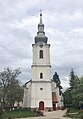
reformed Church

reformed Church

Roman Catholic Church

Stubenberg Palace
.JPG)
.JPG)


Partnerships
-
 Létavértes , Hungary
 -
 Écaussinnes , Belgium
 -
Szeged , Hungary
Web links
Individual evidence
- ↑ 2011 census in Romania ( MS Excel ; 1.3 MB)
- ↑ Website of the Romanian House of Representatives, accessed on January 10, 2008 (PDF file; 3.8 MB)
- ↑ Ferenc Szakály: Hungaria eliberata. The reconquest of Buda in 1686 and Hungary's liberation from Ottoman rule (1683–1718). Corvina, Budapest 1986, ISBN 963-13-2321-8 , p. 21.
- ↑ 2002 census, accessed on January 10, 2008 (PDF file; 1.0 MB)