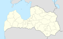
Ilūkste
| Ilūkste ( German : Illuxt) | ||
|---|---|---|
 |
|
|
| Basic data | ||
| State : |
|
|
| Landscape: | ||
| Administrative district : | Ilūkstes novads | |
| Coordinates : | 55 ° 59 ′ N , 26 ° 18 ′ E | |
| Residents : | 2,638 (Jan 1, 2016) | |
| Area : | 9 km² | |
| Population density : | 293 inhabitants per km² | |
| Height : | ||
| Website: | www.ilukste.lv | |
| Post Code: | ||
| ISO code: | ||
Ilūkste ( German Illuxt ) is a city in southeastern Latvia on the border with Lithuania and the center of the administrative district of the same name. In 2016 Ilūkste had 2638 inhabitants.
history
The place was formed in the 16th century at the crossroads of trade routes. In 1559 Illuxt is mentioned for the first time in a document. Illuxt belonged to the Semgallic part of the Duchy of Courland and Semigallia . A Latin school already existed here in 1596 . In the second half of the 17th century, Old Believers also settled in Illuxt .
When the Duchy of Courland and Semgallia fell to the Russian Empire in 1795 , the place became the seat of the Hauptmannschaft in 1798. H. District center (Lat .: Ilūkstes apriņķis). As a result of the construction of the highway from St. Petersburg to Warsaw (completed in 1875) and the railway line from Tilsit to Daugavpils (1873), both of which lead through Ilūkste, Ilūkste experienced an economic boom. In 1897 Ilūkste had 3,652 inhabitants, including 1,355 Poles, 847 Russians, 842 Jews, 360 Latvians, 134 Germans and 99 Lithuanians. In 1910 there was an institute for Russian teachers in Illūkste, which was later moved to Yaroslavl . In 1917 Illūkste received city rights.
Personalities
- Andis Dilāns (* 1970), major general
- Rite Krjauklis (* 1986), football player
- Andris Vaņins (* 1980), soccer goalkeeper
Ilūkstes novads
In 2003 the city of Ilūkste and the municipalities of Pilskalne, Šēdere and Bebrene merged. In 2009 Subate , Dviete and Eglaine were added. 9,062 inhabitants are registered on 648 hectares (as of 2010).
literature
- Hans Feldmann , Heinz von zur Mühlen (ed.): Baltic historical local dictionary, part 2: Latvia (southern Livonia and Courland). Böhlau, Cologne 1990, ISBN 3-412-06889-6 , pp. 228-229.
- Astrīda Iltnere (ed.): Latvijas Pagasti, Enciklopēdija. Preses Nams, Riga 2002, ISBN 9984-00-436-8 .
Web links
Individual evidence
- ↑ «Latvijas iedzīvotāju skaits pašvaldībās pagastu dalījumā"
- ↑ a b Hans Feldmann, Heinz von zur Mühlen (ed.): Baltic historical local lexicon, part 2: Latvia (southern Livland and Courland). Böhlau, Cologne 1990, p. 228.
- ↑ a b c Hans Feldmann, Heinz von zur Mühlen (ed.): Baltic historical local dictionary, part 2: Latvia (southern Livonia and Courland). Böhlau, Cologne 1990, p. 229.
