Information boards about historical buildings and monuments in Hambach an der Weinstrasse
Information boards about historical buildings and monuments are now part of the appearance of many cities and communities. These are then usually attached at the entrance to the town, on parking lots or on buildings and draw the visitor's attention to special information that is of particular importance for economic, religious or architectural reasons. In the Neustadt district of Hambach an der Weinstrasse , too , the idea was taken up in the mid-1990s to make the place with its numerous historical buildings and monuments more interesting and informative for the visitor by installing information boards. After a lot of preparatory work and through the efforts of Hambach citizens, financed by the "Die Hambacher eV" association, the first information boards were installed in October 2001. Further boards were added by 2007.
List of historical buildings
| location | designation | description | image |
|---|---|---|---|
| Andergasse 50 location |
Old noble residence | Two-storey renaissance house with a protruding, semicircular stair tower , partially demolished, original room distribution typical for the Haardtrand: kitchen and hallway between room and stable. Temporary seat of the nobility of the Lords of Saulheim (coat of arms top left: crescent moon with face) - crown stone 1585. |

|
| Andergasse 69–77 location |
Prince-Bishop's forester's house and cattle yard | Group of buildings from the 16th century, consisting of the Jägerhaus and Ökonomiehof (No. 75/77); since the destruction of the Kästenburg (Hambacher Schloß) seat of a lordly head forester; popularly called "Butzelburg". Jägerhaus, originally one-story (No. 71/73): vaulted wine cellar 1601, gate building 1605. Formerly seed drought in the rear courtyard (No. 69). State property during the French Revolution, bought by Kaspar Scharfenberger at an auction in 1823 (at times up to five owners). |

|
| Andergasse 80/81/84 location |
Presumably prince-bishop stables | Located at the foot of the Schlossberg . Hole in the basement: the end of a fabulous underground passage to the Kästenburg? Extensive building complex with components from the Renaissance: lintel in 1574. In the French Revolution owned by the Glas family, today still part owners (restaurant Jägerstübchen with spoils from Hambach Castle ). |

|
| Andergasse 106 location |
Pointed arch from the Kästenburg | Formerly windows in the Kästenburg residential building. Belonging to the so-called mixed style because of the round bar and bossing, around 1250. When the house was built (now owned by the Norbert Glas family), it was installed here as a door frame to the cellar, probably by Johann Adam Finally around 1800. |

|
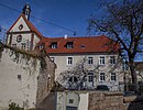
| Enggasse 20 location |
Liebfrauenpfründhaus | Mid-14th century construction of the Frühmesserei "Our Lady" with. Pfründhaus (Benefiziathaus) "in the back corner" below the Heidelberg by pastor and congregation (> Heisel-, Häuselberg?); 1753 new building based on plans by master mason Mathes Fischer, older wine cellar; 1841 Chaplain’s house sold; 1904 rest home for the sisters of St. Magdalena in Speyer, extension of the chapel in 1913; today condominiums. |
|
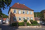
| Freiheitsstrasse 2 location |
Catholic parsonage with parsonage (old memorial plaque Remling) | Parsonage with cathedral capitular tithe cellar, top stone 1759; (Entrance Weinstrasse), barn 1769, demolished in 1977; Pastor Franz Xaver Remling 1833–1852 in Hambach, important Palatinate historian. |
|
| Freiheitsstrasse 4 location |
Jesuit court of the college in Speyer | Taken by the Jesuits before 1637 . Previous owner: Mayor Christmann Hermann from St. Martin, father of a Jesuit father. After the dissolution of the Jesuit order in 1773, he went to the seminary in Bruchsal . In the 19th century owned by the Baader family. Draw well in the courtyard, now covered. |

|
| Freiheitsstrasse 8 location |
Former west wing of the Jesuit court | Renaissance building acquired by the Jesuits of Speyer in 1640 and combined with the neighboring building (east wing) to form a courtyard, previous owner Niclas Groh from Rhodt. In 1670 the west wing was rebuilt (old lintel in the courtyard of the restaurant next door). During the French Revolution, but before 1800, it was again divided into two courtyards. |

|
| Freiheitsstrasse location |
Boundary stone no. 51 and rain retention basin at the Herrschaftlicher Haag | Boundary stone no.51 of the lordly Haagwald (Burgfriedensiertel around the Kestenburg = Hambacher Schloß) at the northeast corner of the former Haagwald border, erected in 1752.
Rainwater retention basin on the former Herrschaftliche Haag, capacity: 1600 cubic meters, discharge into the Hagenbach (today Kanzgraben), max: 800 liters per second |

|
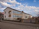
| Horstweg / In the Setz location |
Dr. Albert Finck School | Named after the former minister of education Dr. Albert Finck (1895-1956). Main wing 1956/1958, architect Ludwig Gunzelmann; School building extension 1965/69, architect Michael Goos; Gable sgraffito with glass mosaic: GV = Georg Vorhauer (1956); Aluminum relif on the front wall of the gym with motif scenes from sports. |
|
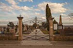
| Horstweg / Diedesfelder Weg location |
New cemetery | New cemetery, laid out with a cemetery cross in 1895, mortuary: built in 1961. Memorial for those who died and those who took part in the war in 1860, 1870/71 (built in 1910) and both world wars. Grave cross for Dr. Albert Fink (1895-1956); Education Minister of Rhineland-Palatinate (1951–1956). |
|
| Jacobusplatz location |
Catholic Church of St. Jacobus | Old fortified church on a foothill of the Heidelberg , first mentioned in 1221; Construction of the choir tower in 1274, including wall paintings with the year 1350; Elevation of the tower and new building of the nave with choir in the west 1747–1750 according to plans by Johann Georg and Johann Leonhard Stahl; baroque interior. |

|
| Jacobusplatz location |
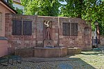
War memorial : First World War and Second World War | Erection of the war memorial in 1928 - Archangel Michael , architect Bernhard Müller - Ruby; Extension 1956 (Second World War); new memorial plaques 1998, Hack Foundry, Eisenberg; in front of the Jacobus – Bronceplatte fountain 1996, Müller-Steinfurt. |
|
| Klosterstrasse 9 location |
Beneficiary St. Katharina | 1331 Foundation of the St. Katharina's early mess workshop by the priest Heinrich Hasse, with the benefice house “on the deep Bronnen” (linden tree) between Enggasse, Hagenbach and Klosterstrasse; 1590 remodeling; 1664 award of the house place in inheritance ; New construction and construction of a wine press house (right); before 1700 division according to inheritance, a little later construction of three new houses on Klosterstrasse. |

|
| Römerweg / Enggasse / Seminargarten location |
Old cemetery (children's playground) | Old cemetery 1819–1896, classical entrance with funerary torches; Cemetery cross from 1823, donated by Jacob Sommer. Children's playground as a result of the incorporation agreement with the city of Neustadt in 1969. |

|
| Schlossstrasse 100 location |
Winery Schäffer Ökonomiehof of the Schlössel Geispitz | Construction and cattle yard outside the curtain wall , the main building with horse, cowshed and barn from the Renaissance period as well as the shepherd's house (1598) originally served for milk and cheese production. Tenth winery of the Hochstift. Well room from 1601, today under the street, jointly owned with Hambach. |

|
| Schlossstrasse 100 location |
Schäffer Schlössel Geispitz winery | Schlössel Geispitz (= Geisberg or Geißbrunnen), after the destruction of the Kästenburg in 1552, alternative quarters for the bishops of Speyer. Renaissance castles from the 16th century have received mighty enclosing walls and portal. Eventful ownership history. |

|
|
Weinstrasse 110 location |
Winegrowers' cooperative Hambacher Schloß | Former winery of Karl Theodor Lichtenberger, built in 1847, sold by the heirs to the Hambach community in 1899, the seat of the Hambach winegrowers' cooperative since 1902, after a fire in 1949 the restaurant was designed by Georg Vorhauer. In Lichtenberg's " Lustgarten " opposite, the Bavarian king was a guest several times. |

|
| Weinstrasse 146 location |
Oberhambach school house | Schoolhouse community, new building in 1724, after a fire, a mansard roof was added (1909); Seat of the municipal administration 1935–1983; today private property. |

|
| Weinstrasse 157 location |
Wilhelminian style manor house Grohé | Built in 1884 by the landowner, wine commissioner, local mayor and member of the Reichstag, Georg Friedrich Grohé, instead of two wineries; 1900 office extension with figure-crowned terrace; 1901 painting of the gate entrance in the Pompeian style by the company Peter Koch from Neustadt; 1966–2003 medical practice; Well pharmacy since 1967. |

|
| Weinstrasse 161 location |
Formerly the prince-bishop's cooperage | Baroque half-timbered house (around 1750); Emblem above the entrance: barrel with crossed hooks (cooperage), above crown (prince-bishop); Baroque stone figure of St. Joseph on the upper floor. In the 18th century the “Zum Weißen Kreuz” inn, later “Zur Goldenen Krone”. Post office from 1955 to 1993. |

|
| Weinstrasse 176 location |
Home of house book author Joseph Angel |
Information board: Street of Democracy ;
Joseph Angel (1802–1870) lived here from 1818 until his death. He gave a remarkably authentic description of the Hambach Festival in 1832 from the “point of view of the simple farmer” (Bühler). |

|
| Weinstrasse 204 location |
Old school house with gym | Erected in 1876 (lintel), today: house of clubs
Gym of the gymnastics club Hambach 1891 eV, expanded in 1997. |

|
| Weinstrasse 240 location |
Voelker / Fuchsbau | Old restaurant, known since 1750; To the vineyard around 1910, (winery owner Adam Disson), Fuchsbau around 1930, so called because of its 74 doors, today: the Voelker family |

|
| Weinstrasse 264 location |
Old town hall with fountain | Baroque building according to plans by the Speyer master builder Johann Georg Stahl 1739/41 under the sovereign Cardinal Damian Hugo von Schönborn (1719–1743). Tower clock from 1868, bell 1826. Sandstone figures of St. Jacobus (1986) and St. Anna (1987) by the sculptor Walter Bauer from Horterhof. Town hall fountain 1911 by architect Bernhard Müller-Ruby, again town hall since 1983. |

|
| Weinstrasse 264 location |
Old Town Hall in Neustadt-Hambach: |
Information board: Street of Democracy ;
The municipal council managed Hambach's participation in the national festival: approval / tolerance of the parade on the Hambach area, renewal of the road network in Ober- and Mittelhambach, instruction of own festival stewards, catering for the festival participants. Authentic description of the events by the Hambach winemaker Joseph Angel in a "house book". Analysis of events by the Palatinate historian and pastor from Hambach (1833–1852) Franz Xaver Remling. |

|
swell
- “The Hambachers ... e. V. “, Association for the Promotion of Village Development, Homeland and Culture Care. Issue 29/2006.