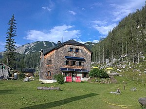
Ischler Hut
| Ischler Hütte ÖAV hut category I. |
||
|---|---|---|
| location | On the Schwarzenbergalm; Styria , Austria ; Valley location: Altaussee | |
| Mountain range | Dead Mountains | |
| Geographical location: | 47 ° 41 '59 " N , 13 ° 45' 38" E | |
| Altitude | 1368 m above sea level A. | |
|
|
||
| owner | ÖAV - section Bad Ischl | |
| Construction type | hut | |
| Usual opening times | June 1 to September 30 - May and October are partially open on weekends | |
| accommodation | 16 beds, 32 camps , 12 emergency camps | |
| Winter room | 12 bearings | |
| Web link | Website of the section | |
| Hut directory | ÖAV DAV | |
The Ischler Hütte is a refuge of the ÖAV section Bad Ischl , in the Styrian Salzkammergut in Austria .
Location and landscape
The house is located in the Dead Mountains at 1368 m above sea level. A. on the Schwarzenbergalm near the state border with Upper Austria , between Altaussee and Bad Ischl . It is located below the Schönberg (Wildenkogel , 2093 m ), the westernmost peaks of the actual Dead Mountains.
history
The Ischler Hütte was built in 1925 by the Bad Aussee section of the OeAV.
In 1982–84 it was completely rebuilt with a striking octagonal floor plan.
Tour possibilities
Approach
From the Rettenbachalm ( 636 m ) near Bad Ischl, the hut can be reached in about 2½ hours on path no. 211 via the former Kainalm.
The hut can also be reached from the Blaa Alm ( 894 m ) near Altaussee in about 2 hours via the Naglsteig , which is secured with ropes .
Transitions
- to the Ebenseer Hochkogelhaus ( 1558 m ) in approx. 2 hours
- to the Ebenseer Hochkogelhaus via the Hochkogel via ferrata (difficulty C / D) via the Vorderen ( 1798 m ) and Hinteren Rauhen Kogel ( 1747 m )
- to the Rinnerhütte over the Schönberg (Wildenkogel) ( 2093 m ) in approx. 6 hours
- to the Albert-Appel-Haus over the Schönberg and the Wildenseehütte ( 1525 m ) in approx. 7 hours
Mountaineering
- Schönberg (Wildenkogel , 2093 m ) in approx. 2½ hours
- On the Schönberg (Wildenkogel) - descent over the east ridge (insured) - through the fire valley - back to the Ischler hut - approx. 7 hours
Winter tours
Ascent to the Ischler Hütte in winter either via summer path No. 211 or through the Bärkogelgraben.
- On the Schönberg in about 2 hours
- On the Vorderen Rauhen Kogel in approx. 1½ hours
- Crossing to the Loserhütte via the Schwarzmoossattel ( 1684 m ) in approx. 5 hours
- Crossing to Wildenseehütte - Weißhorn ( 1754 m ) - Offensee ( 649 m ) in approx. 9 hours
- Starting point for crossing the Dead Mountains: from the Ischlerhütte to the Wildenseehütte - Pühringerhütte - Tauplitzalm - Wurzeralm in approx. 4 days
Other tour destinations
Under the Schönberg and the Vorderen and Hinteren Rauher is the Schönberg cave system , the longest cave in the EU with a total length of 140 km. The cave system has 34 different entrances. The Ischlerhütte is the base of the cave explorers, the entrance to the Raucherkar cave is in the immediate vicinity of the hut. The cave is not open to the public.
Literature & Maps
- Wolfgang Heitzmann: Salzkammergut with the Totem Mountains and Dachstein: high-altitude trails, summit tours, via ferratas . Tour No. 21, pp. 92-94. New edition Bruckmann Verlag, Munich 2002, ISBN 3-7654-3336-5 .
- Alpine Club Map Bl. 15/1 (Totes Gebirge - West), 1: 25,000; Austrian Alpine Club 2014; ISBN 978-3-928777-29-2 .


