Île de Montréal
| Île de Montréal | ||
|---|---|---|
| Satellite photo of the Île de Montréal | ||
| Waters | Saint Lawrence River | |
| Archipelago | Hochelaga archipelago | |
| Geographical location | 45 ° 31 ′ N , 73 ° 38 ′ W | |
|
|
||
| length | 50 km | |
| width | 16 km | |
| surface | 499 km² | |
| Highest elevation |
Mont Royal 233 m |
|
| Residents | 1,900,000 3808 inhabitants / km² |
|
| main place | Montreal | |
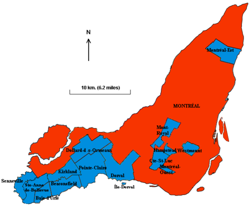
The Île de Montréal (English Island of Montreal , German Insel von Montreal ) is an island in the southwest of the Canadian province of Québec . It is located in the St. Lawrence River , east of the mouth of the Ottawa River . With an area of 499 km² it is by far the largest island in the Hochelaga archipelago . The megacity of Montreal and 14 of the other 15 municipalities of the Montreal agglomeration are located on it . With around 1,900,000 inhabitants, the Île de Montréal is the most populous island in Canada and the most populous inland island in the world. Around a quarter of the population of Québec live here.
geography
The island is 50 km long, up to 16 km wide and has the shape of a boomerang (one point points roughly to the west, the other to the north). The coastline is 266.6 km long. The highest point on the island is the 233 m high Mont Royal , the westernmost of the Montérégie hills .
To the southwest of the island, the St. Lawrence River widens into Lac Saint-Louis , then narrows to the Lachine Rapids and widens to the Bassin de La Prairie, before becoming the Saint Lawrence River again and north-eastwards in Flowing towards the city of Quebec . In the Bassin de La Prairie, south of downtown Montreal, is the Île des Sœurs , east of the city center are the Île Sainte-Hélène and the Île Notre-Dame . The 14.5 km long Lachine Canal runs through the southwest of the island and bypasses the rapids.
The Ottawa River coming from the northwest becomes the Lac des Deux Montagnes , which is connected by two narrow river arms with the Lac Saint-Louis and the Saint Lawrence River. Another outflow of the Lac des Deux-Montagnes, the Rivière des Prairies , flows along the north coast of the island and at the north-east end of the island into the Saint Lawrence River; he separates the Île Jésus with the city of Laval from the Île de Montréal.
Surname
In 1535, the French explorer Jacques Cartier named the hill on the island the Mont Royal. The island itself didn't have a name back then. Samuel de Champlain referred to it on a map in 1616 as Ille de Vilmenon , named after Sieur de Vilmenon, a patron of the founders of Québec at the court of King Louis XIII.
However, from 1632 onwards Champlain named the island Isle de Mont-real on another map . The new name, possibly a translation from Italian, was now derived from the mountain. It was then carried over to the town at the foot of the hill in the first half of the 18th century, which was originally called Ville-Marie .
In the Mohawk language, the island is called Tiohtià: ke Tsi , which refers to the Lachine rapids in the southwest of the island. In Algonquin she is called Moniang .
Communities
15 of the 16 municipalities of the Montreal agglomeration are located on the Île de Montréal. The only exception is L'Île-Dorval on the offshore island of the same name.
- Baie-D'Urfé
- Beaconsfield
- Cote-Saint-Luc
- Dollard-Des Ormeaux
- Dorval
- Hampstead
- Kirkland
- Mont-Royal
- Montreal
- Montréal-Est
- Montréal-Ouest
- Pointe Claire
- Sainte-Anne-de-Bellevue
- Senneville
- Westmount
See also
literature
- Montreal, a City Steeped in History - Guide to Nationality Significant Places, Persons and Events on the Island of Montreal. Parks Canada, Québec 2004. ISBN 0-660-19274-8 .


