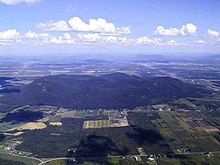
Montérégie hill
The Montérégie Hills (French. Collines montérégiennes , English Monteregian Hills ) are a chain of isolated hills in the Canadian province of Québec . They extend from the city of Montreal about 90 km in an easterly direction and lie north of the Appalachian Mountains . The range of hills is named after Mont Royal (Latin Mons Regius ) in downtown Montreal, the most famous (but not highest) hill. The administrative region of Montérégie is named after the range of hills .
Each of these mounds was formed during the Cretaceous period through the intrusion of igneous rock and horn rock , which are much more resistant to weathering than the surrounding sedimentary rock . This was removed over the course of millions of years, so that the round hills protrude several hundred meters in the otherwise flat plain. The hills consist of dark-colored Mafit rocks such as gabbro and essexite , but also of lighter types of rock such as syenite .
The flat, rocky summit plateaus of the hills are mostly covered with forest. The floors of the lower slopes consist of gravel and sand. The sandy soils are predominantly Podzol with a hard subsoil and therefore not very suitable for agriculture.
From west to east the following hills form the Montérégie chain (MA = age in millions of years):
| Surname | height | Age | local community |
|---|---|---|---|
| Mont Royal | 233 m | 118-138 MA | Montreal |
| Mont Saint-Bruno | 218 m | 118-136 MA | Saint-Bruno-de-Montarville |
| Mont Saint-Hilaire | 411 m | 135 employees | Mont-Saint-Hilaire |
| Mont Saint-Grégoire | 251 m | 119 employees | Mont-Saint-Grégoire |
| Mont Rougemont | 381 m | 137 employees | Rougemont |
| Mont Yamaska | 416 m | 120-140 MA | Saint-Paul-d'Abbotsford |
| Mont Shefford | 526 m | 120-130 MA | Shefford |
| Mont Brome | 553 m | 118-138 MA | Bromont |
| Mont Mégantic | 1105 m | 128-133 MA | Notre-Dame-des-Bois |
Web links
- Geological information (French)
Coordinates: 45 ° 29 ′ N , 73 ° 2 ′ W

