
Saint-Bruno-de-Montarville
| Saint-Bruno-de-Montarville | |||
|---|---|---|---|
 Town hall of Saint-Bruno-de-Montarville |
|||
| Location in Quebec | |||
|
|||
| State : |
|
||
| Province : | Quebec | ||
| Administrative region : | Montérégie | ||
| MRC or equivalent : | Longueuil | ||
| Coordinates : | 45 ° 32 ′ N , 73 ° 21 ′ W | ||
| Height : | 36 m | ||
| Area : | 43.28 km² | ||
| Residents : | 26,107 (as of 2011) | ||
| Population density : | 603.2 inhabitants / km² | ||
| Time zone : | Eastern Time ( UTC − 5 ) | ||
| Municipality number: | 58037 | ||
| Postal code : | J3V | ||
| Area code : | +1 450 | ||
| Mayor : | Martin Murray | ||
| Website : | www.stbruno.ca | ||
 Located in the Longueuil agglomeration |
|||

Saint-Bruno-de-Montarville is a city in the southwest of the Canadian province of Québec . It is located in the administrative region of Montérégie , around 20 km east of Montreal . The city is part of the Longueuil agglomeration , has an area of 43.28 km² and has 26,107 inhabitants (2011). From 2002 to 2006, Saint-Bruno-de-Montarville was a district of Longueuil .
geography
Saint-Bruno-de-Montarville is located in the Rive-Sud region , on the plain between the St. Lawrence River and the Rivière Richelieu . In the northern part of the urban area rises the 218 meter high Mont Saint-Bruno , the lowest of the Montérégie hills . While the hill flanks drop steeply, the summit area is flattened and has several depressions. In these are the lakes Lac Seigneurial, Lac des Bouleaux, Lac du Moulin, Lac à la Tortue and Lac des Atocas. A large part of the hill is protected as the Parc national du Mont-Saint-Bruno . Neighboring municipalities are Sainte-Julie in the north, Saint-Basile-le-Grand in the east, Carignan in the south, Longueuil in the west and Boucherville in the north-west.
history

In 1710, Philippe de Rigaud de Vaudreuil , the governor of New France , transferred the newly created Seigneurie Montarville to Pierre Boucher de Boucherville. In 1723 it was noted that no clearing had yet been carried out and no one had yet settled. The seigneurie remained in the family's possession until 1829 and then passed to the Montreal lawyer François-Pierre Bruneau. In the 19th century there were six water mills that used the water power of Mont Saint-Bruno. Bishop Ignace Bourget created the parish of Saint-Bruno in 1842 after receiving a petition to do so. The name is reminiscent of the former Seigneur Bruneau and Saint Bruno of Cologne ; the addition Montarville is a Portmanteau word from montagne (mountain) and the family name Boucherville. The civil parish was founded in 1855, one year after the abolition of the manor. In 1958 the community received city status.
The government of the province of Québec ordered the merger of several municipalities with the city of Longueuil , which came into effect on January 1, 2002. Saint-Bruno-de-Montarville now formed a district of Longueuil. This approach met with great resistance in parts of the population. In a referendum on January 20, 2004, 72% of the voters were in favor of the separation, whereby the required quorum of 35% yes-votes of all eligible voters was clearly exceeded. The community was re-established on January 1, 2006, but had to cede some competencies to the community association of the agglomeration Longueuil . Saint-Bruno-de-Montarville is a member of the Communauté métropolitaine de Montréal association founded in 2000 .
population
According to the 2011 census, Saint-Bruno-de-Montarville had 26,107 inhabitants, which corresponds to a population density of 603.2 inh / km². 84.4% of the population stated French as their main language, the share of English was 9.3%. 1.2% said they were bilingual (French and English), other languages and multiple answers made up 5.1%. Only French spoke 33.9%. In 2001, 87.5% of the population were Roman Catholic , 5.9% Protestant and 4.7% non-denominational.
Transport and economy
Autoroute 30 runs along the western outskirts of the city . This highway bypasses the Montreal conurbation and continues north to Sorel-Tracy . It crosses the nationally important, partly motorway-like main road Route 116 , which connects Longueuil with Saint-Hyacinthe , Victoriaville and Lévis . Saint-Bruno-de-Montarville is on the main railway line between the cities of Montreal and Québec , and AMT local trains to Mont-Saint-Hilaire stop at the station . Several bus routes operated by the Réseau de transport de Longueuil company provide access to the city.
The Promenades Saint-Bruno shopping center is an important economic factor . With over 250 stores, it is the largest of its kind in the Montérégie region. The Ski Saint-Bruno winter sports area is located on the north-western slope of Mont- Saint-Bruno .
photos
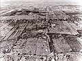
Aerial view from 1952
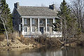
Old rectory

Former train station
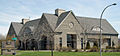
Cultural center


Web links
Individual evidence
- ↑ Saint-Bruno-de-Montarville. Commission de toponymie du Québec, accessed January 9, 2014 (French).
- ↑ Histoire. City of Saint-Bruno-de-Montarville, accessed January 9, 2014 (French).
- ↑ Référendums du 20 juin 2004. Directeur général des élections du Québec, accessed on January 9, 2014 (French).
- ↑ Population profile of the municipality of Saint-Bruno-de-Montarville. In: 2011 Census. Statistics Canada , 2011, accessed January 9, 2014 (French).
- ↑ Population profile of the municipality of Saint-Bruno-de-Montarville. In: 2001 Census. Statistics Canada , 2001, accessed January 9, 2014 (French).