
Mont Saint-Hilaire
| Mont Saint-Hilaire | ||
|---|---|---|
 Mont Saint-Hilaire |
||
| height | 414 m | |
| location | Montérégie , Québec | |
| Mountains | Montérégie hill | |
| Notch height | 380 m | |
| Coordinates | 45 ° 33 '8 " N , 73 ° 9' 3" W | |
|
||
| Type | Inselberg | |
| rock | Intrusive magmatite | |
| Age of the rock | 125 million years | |

The Mont Saint-Hilaire is a 414 meter high mountain in the southwest of the Canadian province of Québec . It is located around thirty kilometers east of Montreal in the area of the city of Mont-Saint-Hilaire , immediately east of the Rivière Richelieu . The area around the mountain is since 1978 Biosphere Reserve of UNESCO , which is open to the public only partially. Most of Mont Saint-Hilaire, which is part of the Montérégie Hills , is owned by Montreal's McGill University .
geography

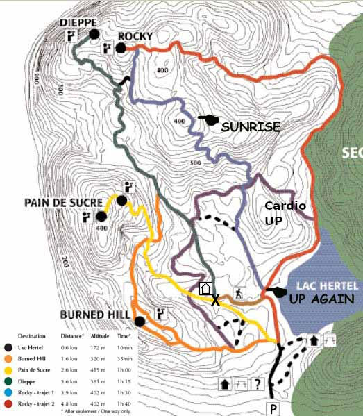
The Mont Saint-Hilaire has a diameter of four kilometers and protrudes almost 400 meters from the surrounding plain. It is thus a landmark that can be seen from afar. The peaks in the western, publicly accessible part are called Pain de Sucre (414 m), Sunrise (405 m), Rocky (403 m), Sommet Dieppe (371 m) and Burnt Hill (320 m). In the eastern part of Mont Saint-Hilaire, which is not open to the public, the peaks usually have no official names; their height ranges from 277 to 392 meters.
A special feature on the south side is the steeply sloping rock face on Sommet Dieppe, the Falaise de Dieppe with a height difference of 175 meters. In the center of Mont Saint-Hilaire is the Lac Hertel, a 0.3 km² large and no more than nine meters deep lake that is fed by three streams. A fourth stream flows from the lake into the Rivière Richelieu . The lake serves as a drinking water reservoir for the region, which is why swimming, fishing and boating are prohibited. The central location of the lake once led to the false assumption that Mont Saint-Hilaire was a volcanic crater; in reality it is the result of glacial erosion .
Geology and Mineral Finds


The bedrock of Mont Saint-Hilaire consists of alkaline plutonites and arose in the Cretaceous period about 125 million years ago from a total of three intrusions : The Sunrise Suite , consisting of the rock types gabbro , pyroxenite and jacupirangite ; the Pain du Sucre-Suite , consisting of the rock types nepheline- gabbro, diorite and monzonite as well as the East Hill-Suite , which occupies the eastern half of the mountain and among other things, intruded into the Sunrise-Suite in the form of a "ring dyke " nepheline and sodalite - syenites , marble - breccia , xenoliths , hornfels and syenitic pegmatites is.
The result of this eventful history is an extraordinary variety of different mineral types and varieties , which made Mont Saint-Hilaire or better its two quarries "Carrière Demix" and "Carrière Poudrette" next to Långban in Sweden and Tsumeb in Namibia one of the most famous and richest mineral find places to have.
Total (as of 2013) about 400 were recognized here so far and some very rare minerals are discovered as, among others, analcime , Baileychlor , Katapleiit , Digenite , Ewaldit , forsterite , graphite , Harmotom , ilmenite , Nenadkevichit , Rhabdophan , Serandit , Thenardite and Willemit .
For 59 of them, Mont Saint-Hilaire is also a type locality such as Bobtraillite , Carletonite , Doyleit , Gaidonnayit , Khomyakovit , Nalipoit , Reederite- (Y) , Sheldrickite , Yofortierite , the minerals named after their type locality, Hilairite and Poudretteit , which is named after the The abenakiite (Ce) mineral named after the indigenous people living in the area and the minerals Hochelagait and Rouvilleit named after a nearby village or community .
Flora and fauna
Mont Saint-Hilaire is home to a wide variety of plants and animals. This diversity is the result of four different ecosystems : the Lac Hertel, the Falaise de Dieppe rock face , pastures and primary forest . The latter is the only remaining fragment of the primary forest that covered the entire Richelieu Valley before the arrival of the first French colonists. In 1978, the Mont Saint-Hilaire was the first Canadian area a biosphere reserve of UNESCO explained. The reserve is managed by the non-profit organization Center de la Nature Mont Saint-Hilaire , founded in 1972 .

The forest of Mont Saint-Hilaire consists mainly of sugar maples and American beeches . Some of these trees are more than 400 years old. There are also bitter nut trees , red oaks , white ash trees , American red pines , Weymouth pines , Canadian hemlocks and American linden trees . Over 600 species of vascular plants are native to Mont Saint-Hilaire, of which more than thirty are considered rare or endangered. Of these, the most frequently represented are daisy family with 73 species (11%), sour grass family with 48 species, rose family with 39 species, sweet grass with 37 species and ferns with 34 species. There is also a large variety of lichens (54 species) and mosses (212 species). The soil at the bottom of the mountain lends itself well to apple orchards , which attract tens of thousands of visitors each year.
The fauna is also extremely diverse. Mont Saint-Hilaire is home to more than 800 species of butterflies , as well as 69 different beetles , 59 different aphids and 27 species of springtails . The 30 species of mammals observed here include squirrels , chipmunks , raccoons , red fox , rabbits , snowshoe hare , American mink , weasel , ermine, and marmots . Even coyotes and white-tailed deer and bobcats can be observed. There are also various amphibians and reptiles. Mont Saint-Hilaire has been a bird sanctuary since 1952 and a migratory bird reserve since 1960. 218 different species of birds can be found here, which is 60% of all species in southern Québec.
history
The indigenous people, the Algonquians and later also the Iroquois used Mont Saint-Hilaire for more than 8,000 years, mainly as a lookout point. There is no evidence of the existence of a village. Samuel de Champlain may have seen the mountain from afar in 1535, but did not go there. In 1609, Jacques Cartier was the first to explore the Richelieu Valley in more detail. The officer Joseph-Baptiste Hertel de Rouville was awarded a seigneury in 1694 , which also included the mountain. Around 1745 a small village was built on the mountain flank. The water power of the stream flowing from the Lac Hertel drove eight mills. From 1844 until its dissolution in 1854, the Seigneurie was owned by Thomas Edmund Campbell. He wanted to develop the mountain for tourism and had an excursion café built at Lac Hertel in 1851, which, however, burned down ten years later. The Iroquois Hotel was built in 1874 and was also destroyed by flames in 1895.
At the end of the 19th century the tourist importance of Mont Saint-Hilaire waned, as the Appalachian Mountains had become much easier to reach due to the advancing development of the Estrie region . Fossil fuels replaced hydropower as an energy source. The inhabitants gave up the settlement on the mountain flank and built new houses on the more favorably situated banks of the Rivière Richelieu. In 1913 the Campbell family sold 890 hectares to the British brigadier and politician Andrew Gault . For decades he worked tirelessly to preserve the natural beauty. In particular, he repeatedly resisted attempts to exploit the mineral resources of the mountain. In 1957 he commissioned the construction of a mansion on Lac Hertel, but he lived there only three weeks before he died. In his will he bequeathed Mont Saint-Hilaire to Montreal's McGill University .
Earlier names
The Algonquians called the mountain Wigwomadensis ( wigwam -shaped mountain) because it reminded of the shape of their dwellings. On his 1612 map of New France , Samuel de Champlain referred to it as Mont Fort , which can be translated as "fortress hill" or "strong mountain". Due to its proximity to the small town of Chambly , the mountain was temporarily called Mont Chambly in the late 17th century (in English this name lasted until around 1830). From 1697, Mont Rouville was common in French , after the seigneurie of the Hertel de Rouville family. When the Campbells replaced the Hertels, the name Mont Belœil became common , after the place Belœil on the opposite side of the Rivière Richelieu. In the early 20th century, however, the name Mont Saint-Hilaire began to dominate when the place of the same name at the foot of the mountain gained importance.
Web links
- Center de la Nature du Mont Saint-Hilaire (French)
- Geology of Mont Saint-Hilaire (English, French)
Individual evidence
- ↑ UNESCO Biosphere Reserves. Mont Saint Hilaire. In: Ecological Sciences for Sustainable Development. UNESCO , August 2013, accessed April 11, 2013 .
- ^ Map of the western part , accessed on January 20, 2014.
- ^ Pierre Lambert: Le Mont Saint-Hilaire . Éditions du Septentrion, Montreal 2007, ISBN 978-2-89448-535-4 .
- ↑ a b c d Flora and Fauna. Center de la nature Mont Saint-Hilaire, September 2003, archived from the original on June 30, 2008 ; accessed on January 20, 2014 .
- ^ The legends of Mont Saint-Hilaire. Center de la nature Mont Saint-Hilaire, September 2003, archived from the original on April 2, 2008 ; accessed on January 20, 2014 .
- ^ Mont Saint-Hilaire in Quebéc, Canada (MSH). Mineralienatlas, 2012, accessed December 20, 2011 .
- ^ Most prolific type localities. MinDat, accessed December 20, 2011 .
- ^ Mont Saint-Hilaire, La Vallée-du-Richelieu RCM, Montérégie, Québec, Canada. MinDat, accessed December 20, 2011 .
- ↑ La conservation et la Mont Saint-Hilaire. Center de la nature Mont Saint-Hilaire, accessed January 20, 2014 (French).
- ↑ Le Mont Saint-Hilaire. Radio-Canada, May 6, 2001, accessed January 20, 2014 (French).
- ↑ a b Réserve naturelle Gault. McGill University, accessed January 20, 2014 (French).
- ^ Protect our Mountain by Eating our Apples. Center de la nature Mont Saint-Hilaire, September 2003, archived from the original on March 10, 2008 ; accessed on December 7, 2011 .
- ↑ a b c Histoire humaine. (No longer available online.) In: Réserve naturelle Gault. McGill University, August 15, 2012, archived from the original February 1, 2014 ; Retrieved January 20, 2014 (French). Info: The archive link was inserted automatically and has not yet been checked. Please check the original and archive link according to the instructions and then remove this notice.
- ^ Mont Saint-Hilaire. Commission de toponymie du Québec, accessed January 20, 2014 (French).
- ^ Map of Lower Canada around 1830 , accessed January 20, 2014.