Hampstead (Quebec)
| Hampstead | ||
|---|---|---|
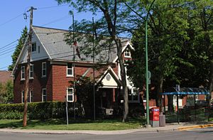
 Hampstead Town Hall |
||
| Location in Quebec | ||
|
|
||
| State : |
|
|
| Province : | Quebec | |
| Administrative region : | Montreal | |
| Coordinates : | 45 ° 29 ′ N , 73 ° 39 ′ W | |
| Height : | 51 m | |
| Area : | 1.79 km² | |
| Residents : | 7153 (as of 2011) | |
| Population density : | 3,996.1 inhabitants / km² | |
| Time zone : | Eastern Time ( UTC − 5 ) | |
| Municipality number: | 66062 | |
| Postal code : | H3X | |
| Area code : | +1 514 | |
| Mayor : | William Steinberg | |
| Website : | www.hampstead.qc.ca | |
 Location of Hampstead in the Montreal agglomeration |
||
Hampstead is a city in the southwest of the Canadian province of Quebec . It is located on the Île de Montréal and forms an enclave within Montreal . The city has an area of 1.79 km² and has 7,153 inhabitants (2011).
geography
Hampstead is located in the central part of the Île de Montréal. The municipality is enclosed on three sides by the area of the city of Montreal, namely by the municipality of Côte-des-Neiges-Notre-Dame-de-Grâce . In the south there is a short border with Côte-Saint-Luc . Downtown Montreal is around eight kilometers away.
history
Hampstead was founded in 1914 as a spin-off from Côte-Saint-Luc . Planned from the start as a garden city , the community developed into a posh suburb of Montreal with a mainly English-speaking, Protestant population. The district of Hampstead in London served as a model . The opening of a golf course and a bus route led to strong growth from the 1930s onwards. After the Second World War, numerous Jewish immigrants from Eastern Europe settled, so that today almost three quarters of the population are of Jewish faith. Hampstead is one of the communities with the highest Jewish population outside of Israel . In 1970 the last available land reserves were built over.
On January 1, 2002, 27 parishes on the island were merged with Montreal. Resistance arose especially in communities with a high proportion of English speakers, as this measure had been ordered by the provincial government of the separatist Parti Québécois . From 2003, the Parti libéral du Québec provided the government and promised to reverse the merger of the municipalities. On July 20, 2004, referendums were held in 22 former municipalities. In Hampstead, 90.4% of voters were in favor of the separation. The community was re-established on January 1, 2006, but had to cede numerous competencies to the community association.
population
According to the 2011 census, Hampstead had 7,153 inhabitants, which corresponds to a population density of 3996.1 inh / km². 59.6% of the population stated English as their main language, while French accounted for 18.3%. 0.9% said they were bilingual (French and English), other languages and multiple answers accounted for 21.2%. The most important non-official main languages were Hebrew (2.7%) as well as Yiddish , Russian , Romanian and Spanish (each 1.5%). 19.9% spoke only English and 4.3% only French. In 2001, 74.2% of the population were Jewish , 10.9% Roman Catholic , 4.2% Protestant , 4.0% Orthodox and 4.3% non-denominational.
traffic
The two major arteries of the city are Fleet Road and Queen Mary Road. Both lead to Autoroute 15 , which runs near the northern outskirts of the city. Hampstead is served by several bus routes operated by the Société de transport de Montréal .
Web links
- Official Website of Hampstead (English)
Individual evidence
- ↑ Hampstead. Commission de toponymie Québec, accessed August 16, 2011 (French).
- ↑ Référendums du 20 juin 2004. Directeur général des élections du Québec, accessed on August 16, 2011 (French).
- ↑ Hampstead Parish Population Profile. In: 2011 Census. Statistics Canada , 2011, accessed January 5, 2014 (French).
- ↑ Hampstead Parish Population Profile. In: 2001 Census. Statistics Canada , 2001, accessed January 5, 2014 (French).
