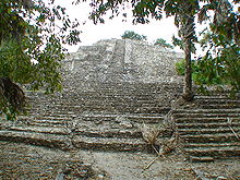
Itzamkanac
Itzamkanac , sometimes named after the nearby modern settlement El Tigre , is an important Mayan ruins on the Yucatán peninsula in the Mexican state of Campeche . The identification with Itzamkanac, the capital of the Acalán Maya, a subgroup of the Chontal Maya or the Putún Maya , is likely, but not certain.
location
The archaeological site Itzamkanac is located southeast of the Gulf of Mexico approx. 23 km southeast of the small town Candelaria on the southern bank of the river of the same name at an altitude of approx. 55 to 60 m above sea level. d. M. Itzamkanac, the capital of the Acalán Maya is said to have been near the mouth of the Río Caribe in the Río Candelaria .
The complex extends on a natural hill on the left bank of the Rio Candelaria and has an area of approx. 5 km².
history
Itzamkanac can be verified as a settlement center archaeologically from the late Mayan pre-classical period . The structures that exist today all date back to the early classical period . Buildings or structures of the post-classical period , in which Itzamkanac was in full bloom until the arrival of the Spaniards as a flourishing commercial center that connected the Mayan regions of Peten and the Gulf coast via a river port of great importance , are largely not preserved.
Hernán Cortés stayed in the city for a few days in 1525 on his way to Honduras to put down the revolt of Cristóbal de Olid . At that time Itzamkanac was divided into four districts and had about 4,000 inhabitants. The Spaniards found around 2000 stone houses in the city, many of which were surrounded by walls. Cortés is said to have impressed the city more than Tayasal, where he had already taken up residence in 1523. The last Aztec ruler Cuauhtémoc and the princes Coanococh from Texcoco , Teplepanquetzal from Tlacopan and Oquici from Azcapotzalco were taken prisoners by Cortés on his expedition. All four were hanged in Itzamkanac on February 28, 1525, following an alleged conspiracy .
In 1525, the elected unrestricted ruler Paxbolonacha was at the head of the government, whose sons were appointed as deputies over the four districts. His brother was the ruler of Nito , a trading post of the Acalán Maya on the Caribbean coast of Guatemala . In the representative temples of the city, mainly Kulkulkan , Ek Chuah and Ix Chel were worshiped alongside other gods .
buildings
The ceremonial center is dominated by 4 large and high buildings, which can be seen as temple pyramids , but also as Mayan acropolis , as they include large platforms on one or more sides at medium height on which there are other buildings that are used as palace or residential buildings are to be addressed. There are also 6 smaller buildings, 2 ball playgrounds , 13 altars and 3 steles. The stairs of the pyramids were accompanied by large stucco masks , which are relatively well preserved because they were covered by later construction phases. Ultimately, one can only speculate about the function of a round structure only approx. 1 m high.
See also
literature
- John W. Fox: Maya Postclassic State Formation . 1987, pp. 19, 34-36, 40, 52, 55, 65-68, 72-73, 97
- John Eric Sidney Thompson : Maya History and Religion . 1990, pp. 5-21, 37, 59, 65-66, 76-79 and the like. 132
Web links
Individual evidence
- ↑ Itzamkanac - topographic map
- ^ France F. Scholes, Ralph L. Roys : Los chontales de Acalan-Tixchel . UNAM, México 1996, ISBN 968-496-303-3 , p. 94.
- ↑ a b Gordon R. Willey (eds.): Handbook of Middle American Indians . Volume 3. 2014, p. 166 f.
- ↑ Tetlepanquetzal . In: James Grant Wilson, John Fiske (Eds.): Appletons' Cyclopædia of American Biography . tape 6 : Sunderland - Zurita . D. Appleton and Company, New York 1889, p. 68 (English, full text [ Wikisource ]).
- ↑ John S. Henderson: The World of the Ancient Maya , pp. 57-58.
Coordinates: 18 ° 7 ′ 19 ″ N , 90 ° 50 ′ 13 ″ W.


