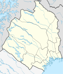
Jäckvik
| Jäckvik | ||||
|
||||
| State : | Sweden | |||
| Province (län): | Norrbotten County | |||
| Historical Province (landskap): | Lapland | |||
| Municipality : | Arjeplog | |||
| Coordinates : | 66 ° 23 ' N , 16 ° 58' E | |||
Jäckvik (sometimes also spelled Jäkkvik ) is a small town in Swedish Lapland on the outskirts of Lake Hornavan .
The place, which belongs to the municipality of Arjeplog , is located on the Silberweg tourist route and is particularly suitable as a starting point for hikes in the nearby Pieljekaise National Park ( Pieljekaise 1133 m above sea level ).
The Jäckvik Fjällcenter is a relatively new ski resort which has existed since the 1997th
The Kungsleden leads through Jäckvik. To the north it is 96 kilometers to Kvikkjokk and to the south it is 86 kilometers to Ammarnäs .
Personalities
- Lars Levi Læstadius , revival preacher
Web links
Jäckvik fjällcenter (Swedish)
literature
Rüdiger Lohf / Michael Hennemann: Sweden: Kungsleden, Stein Verlag 2005
