Jasenitz
| Jasenitz | ||
|
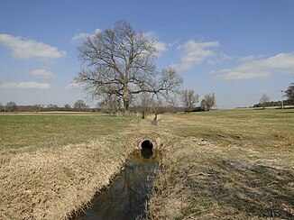
Jasenitz shortly before it flows into the Dobbertiner See |
||
| Data | ||
| Water code | DE : 964434 | |
| location | Mecklenburg | |
| River system | Warnow | |
| Drain over | Mildenitz → Warnow → Baltic Sea | |
| source |
Spendiner See 53 ° 38 ′ 25 ″ N , 12 ° 5 ′ 54 ″ E |
|
| Source height | 46.6 m above sea level NHN | |
| muzzle |
Dobbertiner See Coordinates: 53 ° 37 '2 " N , 12 ° 5' 42" E 53 ° 37 '2 " N , 12 ° 5' 42" E |
|
| Mouth height | 45 m above sea level NHN | |
| Height difference | 1.6 m | |
| Bottom slope | approx. 0.4 ‰ | |
| length | approx. 4 km | |
| Flowing lakes | Lüschow | |
| Communities | Dobbertin | |
The Jasenitz is an approximately four kilometer long tributary of the Mildenitz in the north of the Ludwigslust-Parchim district in Mecklenburg-Western Pomerania . It runs mostly in the municipality of Dobbertin , in the lower reaches partly in the urban area of Goldberg near the border with Dobbertin.
course
The watercourse rises from the Spendiner lake . The associated waterway code 964434 is already assigned to a ditch that rises north of Spendin at the foot of the Hellberg and flows into the Spendiner See on the west bank.
In a south-easterly direction, the Jasenitz flows through the Lüschow , a lake that receives water inflows from the Kleestensee and the Borgsee via ditch connections . At the Goldberg district of Hellberg, the Jasenitz flows into the Dobbertiner See on the northeast bank, which carries its water over the Mildenitz towards Warnow and the Baltic Sea.
history
The Jasenitz brook was first mentioned in 1227 as the border between Gols ( Goldberg ) and Dobrotin ( Dobbertin Monastery ). In 1237 the Jasenitz, which flows into the Jawir Lake (Dobbertiner See), was further confirmed as a border when the monastery area was expanded.
In 1860 the Jasenitz was straightened from the Lüschow to the Dobbertiner See. When the Lüschow water level fell in 1884, the length of the Jasenitz trench had lengthened.
literature
- Franz Engel: German and Slavic influences in the Dobbertiner cultural landscape. Würzburg 1934, VII, pp. 38-43. (Writings of the Geographical Institute of the University of Kiel; Volume II, Issue 3)
cards
- Economic map of the Dobbertin Forestry Office 1727/1928.
Web links
Individual evidence
- ↑ a b Maps of the Mecklenburg-Western Pomerania geoportal
- ^ Environmental maps MV , water lines, water routes LAWA
- ↑ Mecklenburgisches Urkundenbuch (MUB), Volume I. Schwerin 1863, 343
- ↑ MUB 469
- ↑ Goldberg Museum: Forestry records, Dobbertin monastery office. 1424.
