
Joure
 flag |
 coat of arms |
| province |
|
| local community |
|
|
Area - land - water |
19.04 km 2 17.62 km 2 1.42 km 2 |
| Residents | 13,090 (Jan. 1, 2017) |
| Coordinates | 52 ° 58 ′ N , 5 ° 48 ′ E |
| Important traffic route |
|
| prefix | 0513 |
| Postcodes | 8467, 8501 |

Joure ( West Frisian De Jouwer ) is a place in the Dutch province of Friesland . The place is the largest place and at the same time the administrative seat of the municipality De Fryske Marren .
Joure has 13,090 inhabitants (as of January 1, 2017).
Joure has had a town partnership with Drolshagen in the Sauerland since 1969 .
Douwe Egberts was founded in Joure . In 1976, a museum opened in the former buildings of the Douwe Egberts coffee roastery .
sons and daughters of the town
- Jan Nicolaas Bakhuizen van den Brink (1896–1987), Reformed theologian and church historian
- Auke Zijlstra (* 1964), politician
- Danny Noppert (* 1990), darts player
photos

Tower of the Westermeer church, which was demolished in the 18th century

Joure, main street Middelstraat with church
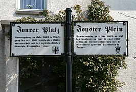
Joure, sign on the Jourer Square in Drolshagen

De Groene Molen
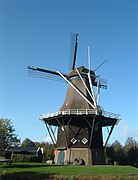
Penninga's moles
_01.jpg)


Web links
Commons : Joure - collection of images, videos and audio files
- Tourist information website (German, Dutch, English, French)
Individual evidence
- ↑ a b Kerncijfers wijken en buurten 2017 Centraal Bureau voor de Statistiek , accessed on June 15, 2018 (Dutch)
- ↑ Website of the city of Drolshagen ( Memento of the original from May 20, 2009 in the Internet Archive ) Info: The archive link was inserted automatically and has not yet been checked. Please check the original and archive link according to the instructions and then remove this notice.