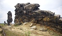
Königstein (Devil's Wall)
The Königstein is a striking rock formation of the Teufelsmauer in the northern Harz foreland in the area of the town of Thale near Weddersleben in the Harz district in Saxony-Anhalt .
location
It extends from northwest to southeast about 500 meters north of the Bode between the northern village of Weddersleben and Neinstedt to the south . A little further to the west are the central stones, which also belong to the Teufelsmauer . On the south side, a hiking trail leads close to the Königstein, but as a circular route it also leads past the north side at a somewhat greater distance. In some cases wooden paths and wooden platforms were built to ensure accessibility for tourists and at the same time the interests of nature conservation . At the eastern end of the Königstein lies the Schlangenecke parcel , at the west the Pflaumenloch . To the southeast of the Königstein is the stamping point 188 of the Harz hiking pin , not far from there is a memorial stone that commemorates an unknown German soldier originally buried here. There is a show garden south of the ascent to Königstein.
Due to the ruggedness and height of its individual rocks, the Königstein is one of the most impressive parts of the Teufelsmauer. At the western end is the devil , also called the western tower. The Adlerfelsen is particularly striking , with a height of 185 m above sea level. NHN highest point of the Königstein. Other distinctive parts to the east are the grandmother and the long wall .
In the area around the Königstein there are orchards . A processed boulder indicates landmarks that can be recognized further away.
Name and story
The name Königstein is derived from the name Kehnstein , which means something like Annunciation Stone .
In September 1784 Johann Wolfgang von Goethe visited the Königstein together with the painter Georg Melchior Kraus . The Goethestein on the south side reminds of this. Around this area there are also historical inscriptions, such as a clef and the curved letter W. In June 1833, the Königstein was placed under nature protection by District Administrator Carl Weyhe , which prevented its long-term use as a quarry .
In 1934/35, during the National Socialist era , a red flag was set on the Königstein. Due to the difficult accessibility, the flag is said to have flown there for almost two years before it could be caught. It turned out that it was a red petticoat that supposedly originally belonged to a wife of an NSDAP member.
Some scenes from DEFA's 1974 film Hans Röckle and the Devil were filmed here. On August 31, 1989, a large rock overturned in the eastern part of the Königstein. Nobody was harmed, but the crash of the collapse could be heard in the surrounding areas.
literature
- Kay Förster: De Düwelsmur tau Wedderslewe . Weddersleben 2006.
- Axel and Volker Mothes: Harzer Klippen- & Stiegenwelt, Volume I. Stiegenbuchverlag, Halle (Saale) 2011, pp. 144 ff.
- Brochure accompanying the Harzer Teufelsmauer Stieg . Ed .: Förderverein Teufelsmauer Weddersleben, 2009, p. 16.
Individual evidence
- ↑ Kay Förster: De Düwelsmur tau Wedderslewe . Weddersleben 2006, pp. 21, 24
- ↑ Kay Förster: De Düwelsmur tau Wedderslewe . Weddersleben 2006, p. 64
- ↑ a b Kay Förster: De Düwelsmur tau Wedderslewe . Weddersleben 2006, Figure 23
- ↑ Kay Förster: De Düwelsmur tau Wedderslewe . Weddersleben 2006, p. 7
- ↑ Kay Förster: De Düwelsmur tau Wedderslewe . Weddersleben 2006, p. 13
- ↑ Kay Förster: De Düwelsmur tau Wedderslewe . Weddersleben 2006, p. 23 f.
Coordinates: 51 ° 45 ′ 27.2 " N , 11 ° 5 ′ 2.2" E


